

Dear beach bum foreign readers, Tita S will feature the beautiful sandbars in the Philippines. This first one is considered the longest sandbar in the country!
Panampangan Island is a secluded, pristine, 12-hectare island in the municipality1 of Sapa-Sapa2, in the province3 of Tawi-Tawi4, in the Sulu Archipelago5, in the Celebes Sea. It is located in the Bangsamoro Autonomous Region in Muslim Mindanao (BARMM)6 of the Philippines. It has an area of 0.1 sq.km. (0.039 sq.mi.).
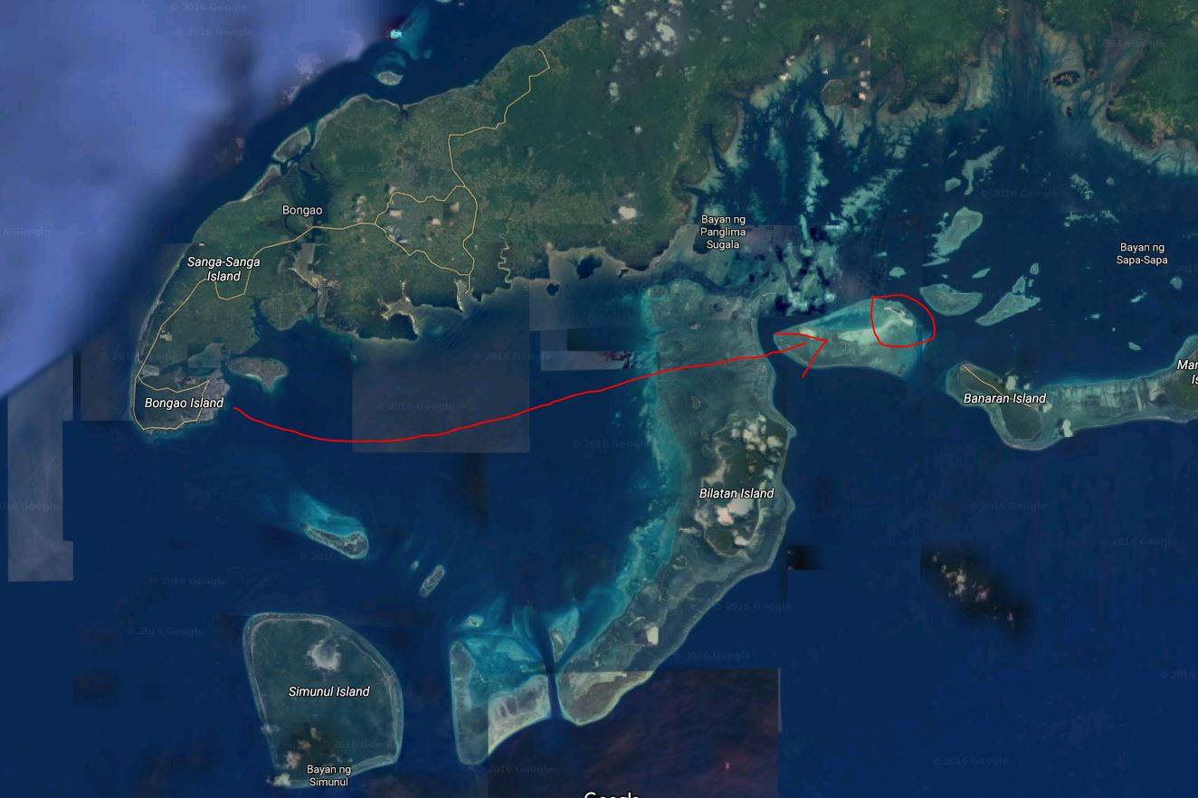
Photo source: https://www.facebook.com/Progressive.Bangsamoro/photos/pcb.1701410416845884/1701410153512577
At the center of the island are coconut trees and lush greenery, that are surrounded by fine white sand beach and crystal clear water.
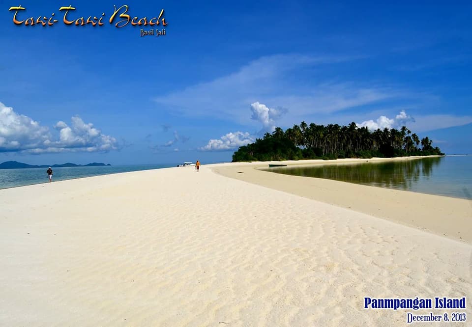
Photo source: https://www.facebook.com/Panampangan-Island-Sapa-Sapa-Tawi-Tawi-Philippines-254359578313396/photos/457717334644285
It is said to have the finest sand among all the beaches in the Philippines!
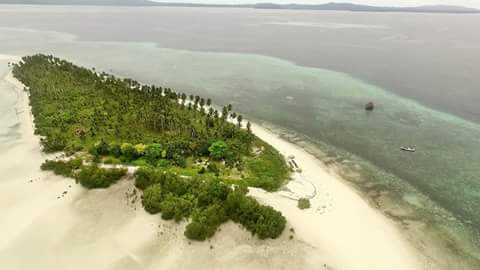
Photo source: https://www.facebook.com/Panampangan-Island-Sapa-Sapa-Tawi-Tawi-Philippines-254359578313396/photos/257742444641776
It takes 2-3 hours by outrigger boat, or less than an hour by speedboat, one way, to reach this island. There are grilling areas where tourists can picnic, and cottages and huts where you can stay overnight, but level your expectations.
The water around the beach is shallow so those who do not know how to swim can just dip on the shallow waters, and will be treated to seeing starfish and a variety of fish.
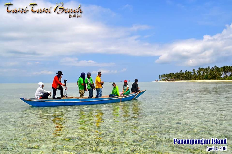
Photo source: https://www.facebook.com/Panampangan-Island-Sapa-Sapa-Tawi-Tawi-Philippines-254359578313396/photos/457717024644316
Those who can snorkel could even see turtles.
It is located inside Basibuli Shoal, and once the tide drops, a crescent-shaped 3,128.37 m. (10,263.7 ft.) sandbar appears.
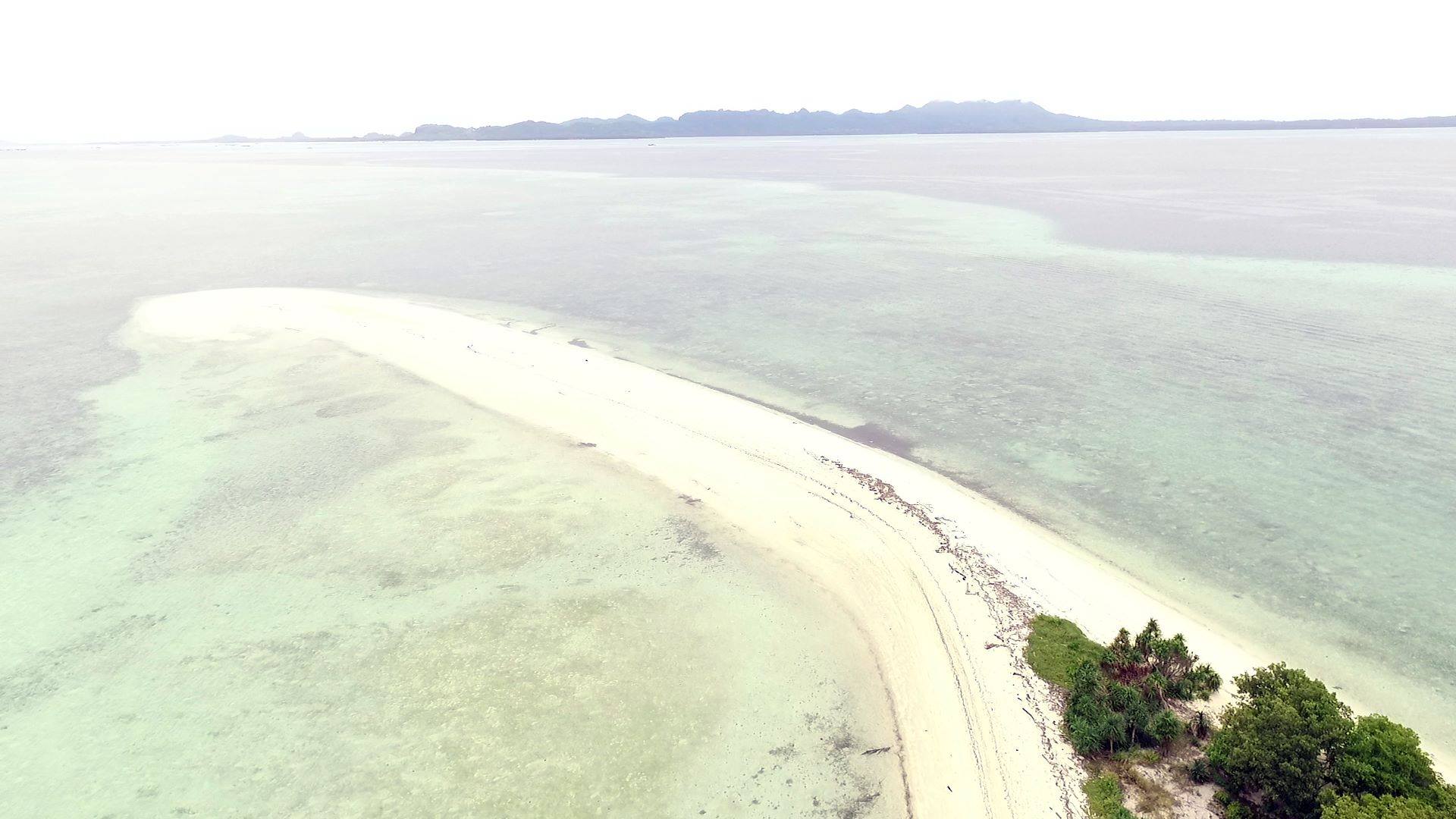
Photo source: https://www.facebook.com/Progressive.Bangsamoro/photos/pcb.1701410416845884/1701383573515235
Being a little over 3 km., it connects to the nearby Basibuli Island. It is considered the longest sandbar in the Philippines.
Watch this 2020 10-minute, 1-second video: https://www.youtube.com/watch?v=gkFWDXs_1-Y
How do you get to Panampangan Island? From Manila, fly directly to Tawi-Tawi4. It is required that you contact and coordinate with the Tawi-Tawi Provincial Tourism Office (https://www.facebook.com/OfficialTawiTawiTourism/ or get their contact numbers), the Department of Tourism-ARMM Office, or the Municipality of Sapa-Sapa. They can also assist you in arranging for a boat and a tour guide for a one- day-island-hopping tour. There is no fixed price, and it could range from PHP6,000 – 10,000.
You can include Simunul Island and Sangay Siapo Island in the tour. Inform them if you want to dive.
The tour can start at 6:00 AM. Go to the port via tricycle, and locate the boat to take you to this island. Be aware that the boat ride could be rough from July to December.
These islands are not developed so you better bring food and water for the whole day, fully charged cameras, GoPros and power banks, swim wear and change of clothes, snorkeling/diving gear, personal medicine, etc.
The Badjaos who live in nearby islands go to Panampangan Island to sell fish, seaweeds, sea urchins and seashells. You can enjoy them for lunch or dinner, if you will stay overnight.
Now, Tita S knows what you are worried about. How safe is Tawi-Tawi4? Do not be scared because she was able to research and found out that there is a naval base in Panglima Sigala and the Philippine Coast Guard regularly patrols Panampangan Island.
The information was obtained from https://primer.com.ph/travel/2018/03/19/panampangan-beach-in-tawi-tawi-paradise-at-the-southernmost-tip-of-the-philippines/, https://www.esquiremag.ph/the-good-life/pursuits/best-secret-beaches-in-the-philippines-a00208-20190211, https://guidetothephilippines.ph/articles/islands-and-beaches/best-sandbars-philippines, https://www.s1expeditions.com/2017/06/217-panampangan-islandtawi-tawi.html and the Wikipedia page “Panampangan Island”7.
Tita S has not been to Tawi-Tawi4 so she cannot personally comment about this island but will surely include it in her Tawi-Tawi travel bucket list.
This is not a sponsored post. I just want my readers to know more about the Philippines.
Did you find this post informative? I would like to hear from you regarding Panampangan Island.
See other interesting places through other posts in this category and other categories of SCapades, Pinoy Delights, and Smart Travelers – Foreign Travelers Ask, Now You Know, and Say, Say, Say. Happy reading, and I hope that you will appreciate what I shared and some of the featured destinations will be part of your future travel plans!
Do share this post with your Facebook friends, follow me by clicking on the bottom right corner of your device, and do not forget to like this post. Thank you.
– – – – – – – – – – – – – – – – – – – – – – – – – –
The following terms are defined for interested readers, especially those with “Senior-Moments”, those not familiar with the terms used in this post, and those too busy or lazy to Google such terms:
1A municipality is small, single urban administrative division, or local government unit (LGU)8, in the Philippines which has corporate status and powers of self-government or jurisdiction as granted by law. It is a unit under a province3, subdivided into barangays9, and is called town, or bayan.
In the Philippines, a municipality is headed by a mayor, a vice-mayor, and members of the Sangguniang Bayan (legislative branch). It can enact local policies and laws, enforce them, and govern its jurisdictions. It can enter into contracts and other transactions through its elected and appointed officials, and can tax as well. It enforces all local and national laws. The information was obtained from Wikipedia page “Municipalities of the Philippines.”10
2Sapa-Sapa is a 3rd class11 municipality1 in the province3 of Tawi-Tawi4, in the Sulu Archipelago5, in the Bangsamoro Autonomous Region in Muslim Mindanao (BARMM)6 of the Philippines. It has a total area of 235.61 sq.km. (90.97 sq.mi.) and has 23 barangays9. The information was obtained from Wikipedia page “Sapa-Sapa.”12
3A province is the primary administrative and political division in the Philippines. It is the second-level administrative sub-division of a region13. There are 81 provinces (called lalawigan) in the Philippines. Each province is governed by an elected legislature called the Sangguniang Panlalawigan, and by an elected governor. In the Philippines, a province is divided into cities and municipalities1 (or towns), which in turn, are divided into barangays9, formerly called barrios. The information was obtained from Wikipedia page “Provinces of the Philippines.”14
See a related post: Foreign Seniors Ask: WHAT ARE PROVINCES IN THE PHILIPPINES?
4Tawi-Tawi is an island province3 in the Bangsamoro Autonomous Region in Muslim Mindanao (BARMM)6 of the Philippines. It is part of the Sulu Archipelago5, and consists of Tawitawi Island, its main island, and 106 surrounding islands and islets, with a combined land area of 1,087.4 sq.km. (419.8 sq.mi.).
It was founded on September 11, 1973. It has 11 municipalities1 and its capital is the municipality of Bongao.
It is the southernmost province of the country, sharing sea borders with the Malaysian state of Sabah and the Indonesian North Kalimantan province, both on the island of Borneo to the west. It is located between the Sulu Sea in the north and the Celebes Sea in the south. To the northeast lies the province of Sulu.
The information was obtained from Wikipedia pages “Tawi-Tawi”15 and “Tawi-Tawi Island”16.
5The Sulu Archipelago is a chain of islands in the Pacific Ocean, in southwestern Philippines, an important migration route for birds. It forms the northern limit of the Celebes Sea and southern limit of the Sulu Sea. Its islands are within the Mindanao17 island group, consisting of the provinces3 of Basilan, Sulu and Tawi-Tawi4, so the archipelago is sometimes referred to as Basulta, derived from the first syllables of the 3 provinces.
The archipelago belongs to the Bangsamoro Autonomous Region in Muslim Mindanao (BARMM)6, excluding the city of Isabela in province of Basilan which was placed under another region – Region 9, Zamboanga Peninsula.
It is not true that this archipelago is the remains of a land bridge between Borneo and the Philippines; it is actually the exposed edge of small submarine ridges produced by tectonic tilting of the sea bottom. Basilan, Jolo, Tawitawi and other islands in the group are extinct volcanic cones rising from the southernmost ridge.
This archipelago is the home of the indigenous Tausug people18 who speak the Tausug language19.
The information was obtained from Wikipedia page “Sulu Archipelago.”20
6Bangsamoro Autonomous Region in Muslim Mindanao (BARMM), or Bangsamoro, is an autonomous region13 located in southern Philippines. It replaced the Autonomous Region in Muslim Mindanao (ARMM) after the creation of the Bangsamoro Organic Law, signed by President Rodrigo Duterte on July 26, 2018. It is currently in transition until 2022.
Bangsamoro literally means “Moro nation” or “Moro country”. This region consists of 5 provinces3 (Basilan except Isabela City, Lanao del Sur, Maguindanao, Sulu and Tawi-Tawi4), 116 municipalities1 and 3 component cities21 (Cotabato City, Lamitan and Marawi).
The information was obtained from the Wikipedia page “Bangsamoro”.22
7“Panampangan Island,” accessed April 2, 2018, https://en.wikipedia.org/wiki/Panampangan_Island
8A local government unit (LGU) in the Philippines is divided into 3 levels: provinces3 and independent cities23; component cities21 and municipalities1; and, barangays9, according to Wikipedia page “Local government in the Philippines”.24
9A barangay in the Philippines is the smallest administrative division in the Philippines, headed by a barangay captain, aided by a Sangguniang Barangay (Barangay Council). It is the native Filipino term for a village. It was formerly called a barrio. In a metropolitan area, a barangay is an inner city neighborhood, a suburb, or a suburban neighborhood. The word barangay originated from the term balangay, a kind of boat used by a group of Austronesian people who migrated to the Philippines. A number of barangays grouped together is called a district. The information was obtained from Wikipedia page “Barangay.”25
10“Municipalities of the Philippines,” accessed October 13, 2019, https://en.wikipedia.org/wiki/Municipalities_of_the_Philippines
11A third class municipality1 in the Philippines has an average annual income for a 4-year period of 240 million, but less than 320 million pesos, according to the Wikipedia page “List of cities of the Philippines.”26.
12“Sapa-Sapa,” accessed April 2, 2018, https://en.wikipedia.org/wiki/Sapa-Sapa
13A region is an administrative division based on geographical, cultural and ethnological characteristics. Each region is further subdivided in provinces3, composed of cities and municipalities1 (or towns), which in turn, are divided into barangays9, formerly called barrios, according to Wikipedia page “Regions of the Philippines” 27.
See a related post: Foreign Seniors Ask: WHAT ARE THE REGIONS OF THE PHILIPPINES?
14“Provinces of the Philippines,” accessed July 17, 2018, https://en.wikipedia.org/wiki/Provinces_of_the_Philippines
15“Tawi-Tawi,” accessed April 2, 2018, https://en.wikipedia.org/wiki/Tawi-Tawi
16“Tawi-Tawi Island,” accessed April 2, 2018, https://en.wikipedia.org/wiki/Tawi-Tawi_Island
17Mindanao is one of the 3 major geographical divisions of the Philippines. It is the second largest island of the country and covers 6 administrative regions13: Caraga, Davao, Northern Mindanao, SOCCSKSARGEN, Zamboanga Peninsula, and the Bangsamoro Autonomous Region in Muslim Mindanao (BARMM)6. It is composed of 22 provinces3 and 33 cities (27 provinces and 33 cities, if associated islands are included). The information was obtained from Wikipedia page “Mindanao.”28 Mindanao is located in the southern part of the country; the 2 other geographical divisions of the Philippines are Luzon (in the northern part) and Visayas (the middle part).
18The Tausug, or Suluk, are an ethnic group of the Philippines and Malaysia. A small population is also found in the northern part of North Kalimantan, a province of Indonesia.
The Tausugs originally had an independent state known as the Sultanate of Sulu, which once exercised sovereignty over the present day Philippine provinces3 of Basilan, Palawan, Sulu, Tawi-Tawi4, Zamboanga City, North Kalimantan (Indonesia), and the eastern part of Sabah (Malaysia).
They are part of the wider political identity of Muslims of Mindanao17 and the provinces of Sulu and Palawan. Most of the Tausugs have converted into the religion of Islam whose members are now more known as the Moro group, who constitute the 3rd largest ethnic group of Mindanao, Sulu and Palawan.
The information was obtained from the Wikipedia page “Tausug people”.29
19The Tausug language is an Austronesian language spoken in the province3 of Sulu in the Philippines and in the eastern area of the state of Sabah, Malaysia, by the Tausug people18, an ethnic group in Malaysia and Mindanao17, Sulu, and southern Palawan in the Philippines. The information was obtained from the Wikipedia page “Tausug language”.30
20“Sulu Archipelago,” accessed April 2, 2018, https://en.wikipedia.org/wiki/Sulu_Archipelago
21A component city (CC) is a type of city in the Philippines which does not meet the requirements of a highly urbanized city31. It is under the jurisdiction of a province2. If such a city is located along the boundaries of 2 or more provinces, it shall be considered part of the province of which it used to be a municipality1. The information was obtained from the Wikipedia page “Cities in the Philippines.”26
22“Bangasamoro,” accessed April 2, 2018, https://en.wikipedia.org/wiki/Bangsamoro
23An independent city in the Philippines is no longer subject to review by any province’s Provincial Board (Sangguniang Panlalawigan), stops sharing its tax revenue with any province3, and is directly supervised by the President of the Philippines. There are currently 38 independent cities in the Philippines.
See a related post: Foreign Seniors Ask: HOW MANY CITIES ARE THERE IN THE PHILIPPINES?
There are 2 kinds of independent cities:
* Highly urbanized city (HUC) – This is a city with a minimum population of 200,000 inhabitants, as certified by the Philippine Statistics Authority, and with the latest annual income of at least PHP50 million or US$1 million, as certified by the City Treasurer. There are currently 33 such cities in the Philippines.
* Independent component city (ICC) – This is a city has a charter that explicitly prohibits its residents from voting for provincial officials. There are currently 5 such cities: Cotabato, Dagupan, Naga (Camarines Sur), Ormoc and Santiago.
The information was obtained from Wikipedia page “Cities of the Philippines”.26
24“Local government in the Philippines,” accessed April 2, 2018, https://en.wikipedia.org/wiki/Local_government_in_the_Philippines
25“Barangay,” accessed July 9, 2018, https://en.wikipedia.org/wiki/Barangay
26“List of cities in the Philippines,” accessed April 2, 2018, https://en.wikipedia.org/wiki/List_of_cities_in_the_Philippines
27“Regions of the Philippines,” accessed July 17, 2018, https://en.wikipedia.org/wiki/Regions_of_the_Philippines
28“Mindanao,” accessed April 2, 2018, https://en.wikipedia.org/wiki/Mindanao
29“Tausug people,” accessed March 18, 2021, https://en.wikipedia.org/wiki/Tausug_people
30“Tausug language,” accessed March 18, 2021, https://en.wikipedia.org/wiki/Tausug_language


