

Dear foreign readers, allow Tita S to tell you about a famous tourist destination in Siargao.
Magpupungko is the most popular tourist destination in the municipality1 of Pilar2, in the east coast of the island of Siargao3, in the province4 of Surigao del Norte5, in the Caraga6 Region7 of Mindanao8, Philippines.
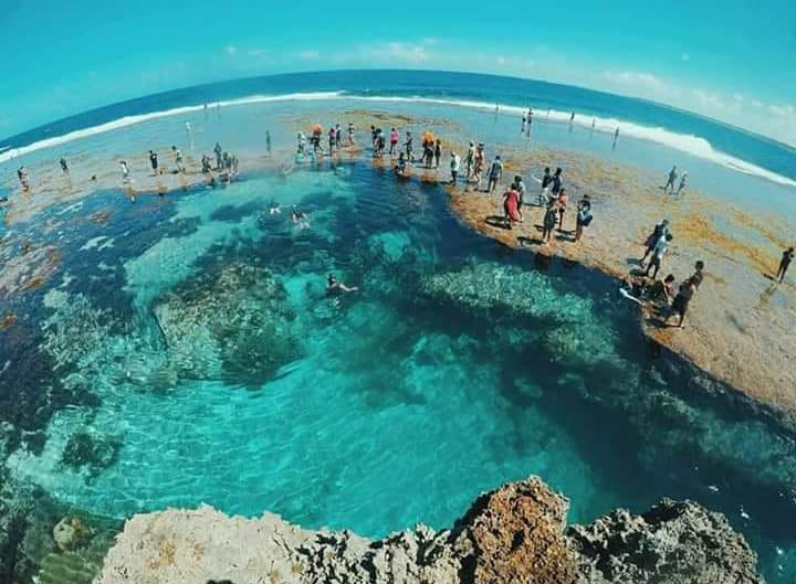
Photo source: https://www.facebook.com/pilarsiargaoisland/photos/2351225454888281
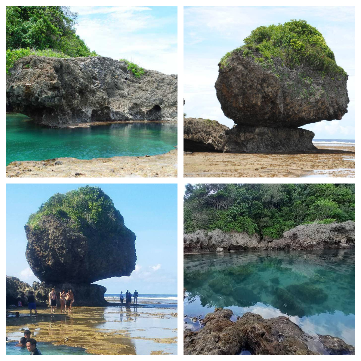
Sources of photos featured in the photo-collage (top-bottom, l-r): https://www.facebook.com/pilarsiargaoisland/photos/a.676745119002998/676744989003011, https://www.facebook.com/pilarsiargaoisland/photos/a.676742392336604/676742405669936, https://www.facebook.com/pilarsiargaoisland/photos/1506169709393864 and https://www.facebook.com/pilarsiargaoisland/photos/2562231053787719
It is known for its beach, limestone rock formations, and natural tidal pools during low tide.
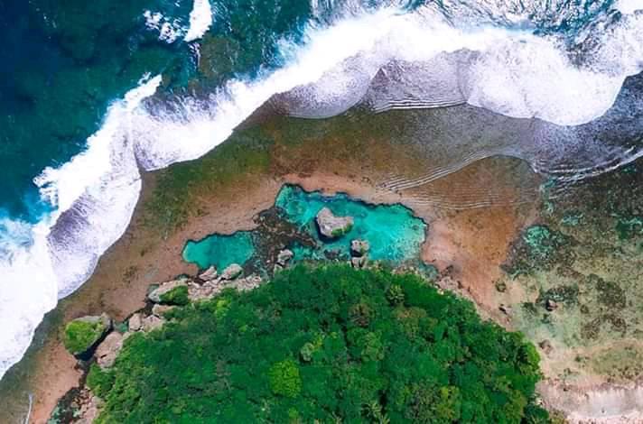
Photo source: https://www.facebook.com/pilarsiargaoisland/photos/2348038968540263
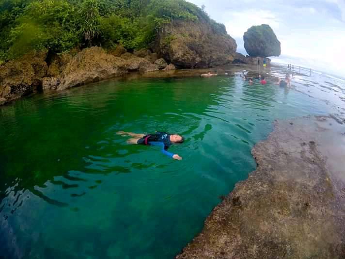
Photo source: https://www.facebook.com/pilarsiargaoisland/photos/2485066348170857
You can swim in the pools, with the main pool being 3 meters deep. You can also swim through small caves, explore the rocky coastline and coves, and for the daring, do some cliff jumping and land in crystal clear blue waters.
The Magpupungko Beach is considered one of the best beaches in Siargao3! There is also the famous balancing rock near the tidal pools.
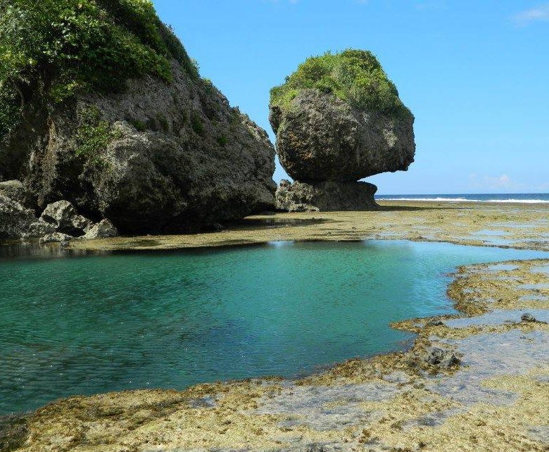
Photo source: https://www.facebook.com/pilarsiargaoisland/photos/a.676742392336604/678577168819793/
Of course, take lots of pictures and videos!
See this 1-minute 15-second video: https://www.facebook.com/DiscoverCaragaPh/videos/4676972685675790/
Magpupungko is just a 45 minute-drive from General Luna9, the main tourist hub of Siargao3.
March to October is the peak tourist season in Siargao, although there could be rain showers and thunderstorms. Surfers are advised to time their visit from August to November for more consistent waves in the surfing spots.
The easiest way to visit Magpupungko is to book a day tour so you do not have to worry about details, itinerary, etc. Google packages, compare prices, itineraries and inclusions. You can also ask your resort where you will stay or their contacts among local tour operators.
You can go DIY, check out the time of low tide, and hire a tricycle. The younger generation, however, rent a motorcycle for about PHP400 (US$7.91) a day, or for long-staying backpackers, opt for a weekly or monthly rental which is cheaper.
Heads up: be sure to time your visit. It is advisable to arrive 2 hours before low tide because most people arrive during the peak of low tide. Furthermore, if it is high tide, you might not be allowed access to the tidal pools for safety reasons.
In addition, locals go to this place during weekends and holidays so why not visit this place during a weekday. If you do not like too many people, why not choose a day when the low tide is early morning so you can have the place to yourself, or at least, there will be less people around.
By the way, do not worry about road trips on this island; there is no traffic and there are no potholes!
Apply sunscreen 30 minutes before your trip, wear comfortable clothes, preferably with your swimwear on underneath. Wear aqua shoes, or an old pair of trainers, to safely climb rock formations that have very sharp and jagged edges. Wear a hat or cap to protect against the sun. Fully charge your cellphone, camera, power banks, GoPro, etc.
Bring a dry bag for your own food (if any), water, medicine (if applicable), change of clothes, towel, basic toiletries, sun screen, cash, power bank/s, etc. Hold on to your entrance ticket so you can go in and out of the beach.
The entrance fee for Magpupungko Beach and Rock Pools is PHP50 (US$0.99). A PHP5 (US$.10) government fee per motorcycle is charged once you turn to the road towards Magpupungko, and there is also a PHP20 (US$.40) parking fee per motorcycle at the entrance. For group tours, these fees are already included.
From the parking area, you get to see the Magpupungko Beach before you reach the tidal pools. You can spend more time in this beach after your tidal pool adventure. There are coconut trees nearby to provide shade, and food stalls, offering local food for lunch, snacks, and refreshments, are located there too.
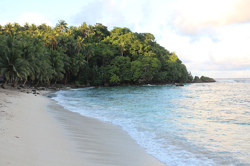
Magpupungko Beach – Photo source: Wolfgang Hagele, own work, CC BY-SA 4.0, created 28 April 2018, https://en.wikipedia.org/wiki/Siargao#/media/File:Magpupungko_Beach_high_tide.jpg
If you arrive a couple of hours before low tide, you can enjoy Magpupungko Beach and personally witness as the tide starts to go out to reveal the beautiful tidal pools.
Make the most of the low tide and opt for the largest or main tidal pool first so you take lots of photos and videos before the influx of visitors, have enough space to swim and cliff dive, if desired. Be sure to wear your aqua shoes to climb the jagged rocks.
The main tidal pool is surrounded by smaller pools. After staying in the former, and more and more people are already there, you could just head over to the smaller tidal pool near the balancing rock since there will be less people there. Be sure to take pictures with this rock, called the Magpupungko Rock, as your background. Or, if the low tide still lasts for some time, and you are adventurous, go to a place called Secret Beach, a small beach past the balancing rock, along the reef, and take lots of pictures there too. They say that only a few people go to this beach. Remember, it should still be low tide when you return from this beach because it would be difficult to return during high tide.
There are restrooms with showers on the far right of Magpupungko Beach.
Based on the timing of the low tide, you can pass by 4 attractions, before or after your visit to Magpupungko:
* Palm Viewpoint – This is located in a small lay way at the side of the road where you can see endless coconut trees, said to be the best lookout in the island.
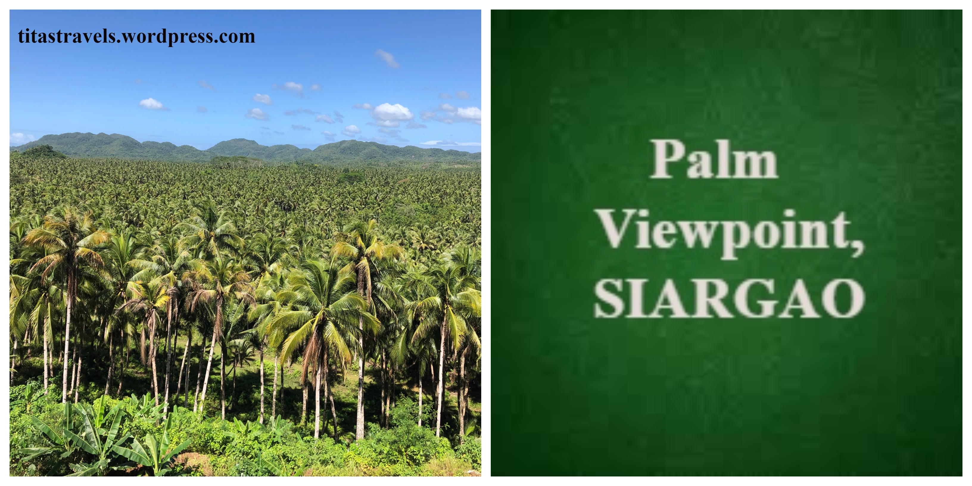
See my post: FOR NATURE LOVERS, DO NOT MISS PALM VIEWPOINT (Siargao, Surigao del Norte, Philippines)
* Palm Tree Road – This is a straight stretch of the road going towards Magpupungko where coconut trees are lined on both sides of the road, branching out like a canopy. A drone shot would be awesome, or you can take a picture standing in the middle of the road.
* Maasin River Palm Tree Rope Swing – You will reach the barangay10 called Maasin after the Palm Tree Road. Once you cross a bridge, you will find the tree rope swing. Are you game enough to swing, or just watch the local kids show you how it is done?
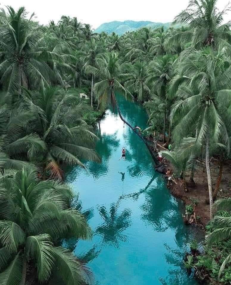
Photo source: https://www.facebook.com/siargaoMaharlika/photos/a.1245592985593857/1303736069779548/
* Tayangban Cave Pool – People usually go here on their way home, after Magpupungko. There is a PHP100 (US$1.97) entrance fee which includes the services of a guide who will take you through the cave system. A lagoon awaits you at the end of the system where you can cliff jump into the pool below.
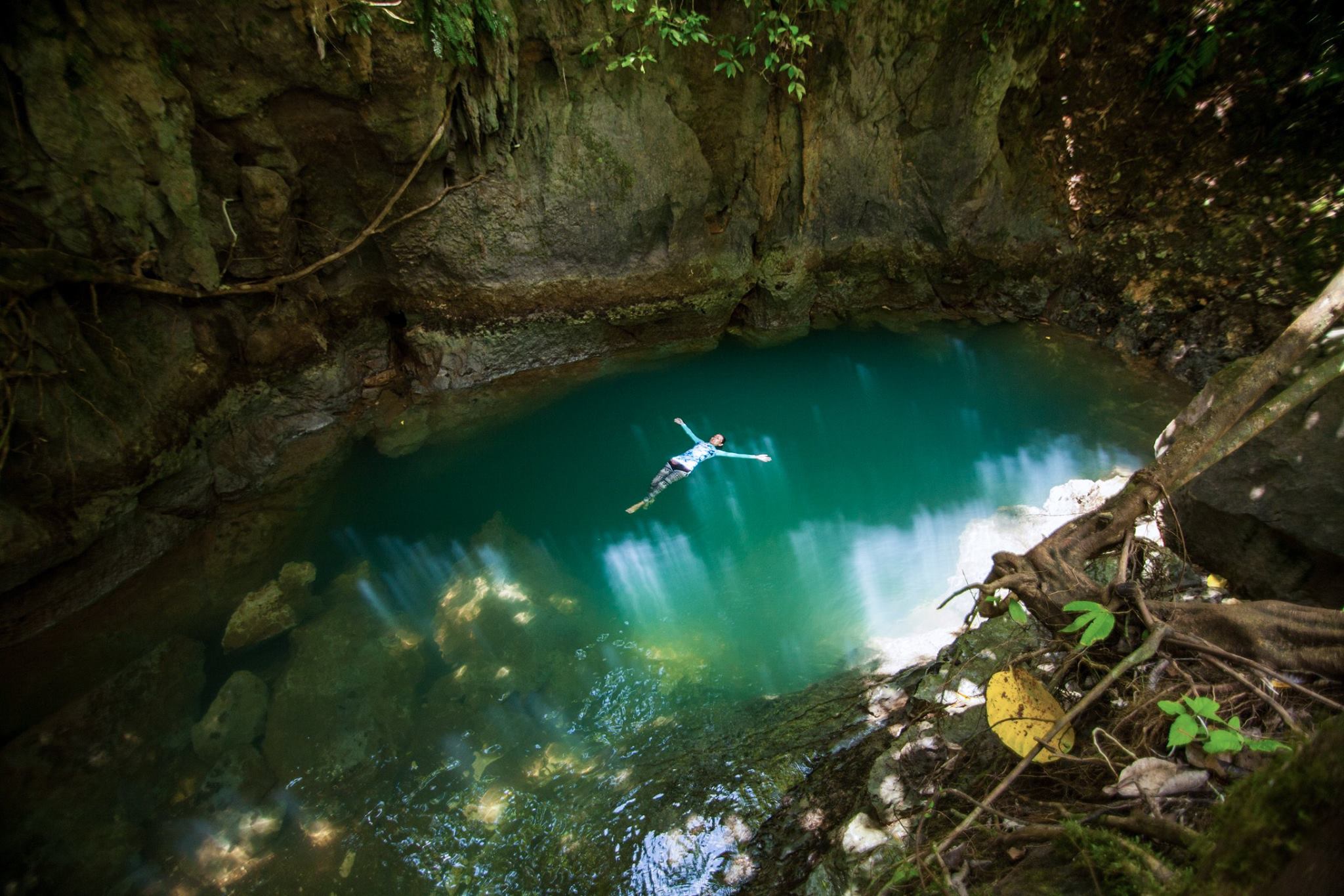
Photo source: Janos Leo Gorgoban Andanar, 10 October 2017. featured in the Facebook account of Surigao del Norte Toursim and Culture Office, https://www.facebook.com/surigaodelnortetourismoffice/photos/ms.c.eJwzNDGzNDA3MbK0tACRRnqGEAFjIzNTEwNLUzMAc44GyQ~-~-.bps.a.817933788321683/1469074299874292/
The information was obtained from the Wikipedia page “Pilar, Suragao del Norte”11 and interviews of friends who visited this place.
Unfortunately, when I went to Siargao3, I missed going to Magpupungko so when I return to this island, for sure I will visit it!
Read my other posts about Siargao: SUN, SAND AND SEA AT GUYAM, DAKU AND NAKED ISLANDS (Siargao, Surigao del Norte, Philippines), SIARGAO’S CLOUD 9 BOARDWALK AND SURFING VIEWING DECK (Siargao Island, Surigao Del Norte, Philippines), SUGBA LAGOON-KAWHAGAN ISLAND TOUR (Siargao, Surigao del Norte, Philippines), NOW YOU KNOW: CLOUD 9 (Siargao, Surigao del Norte, Philippines), FOR NATURE LOVERS, DO NOT MISS PALM VIEWPOINT (Siargao, Surigao del Norte, Philippines), CEV: Ceviche Heaven in Siargao, A HEALTHY ALTERNATIVE AT SHAKA (Siargao, Surigao del Norte, Philippines) and Seniors, Now You Know: S.E.A. MOVEMENT – FIGHTING TO PRESERVE SIARGAO!
This is not a sponsored post. I just want my readers to know more about the Philippines.
Sources of photos featured in the cover photo-collage (top-bottom, l-r): https://www.facebook.com/pilarsiargaoisland/photos/1249364468407724, https://www.facebook.com/pilarsiargaoisland/photos/a.676742392336604/678577168819793/, https://www.facebook.com/pilarsiargaoisland/photos/2311152788895548 and Wolfgang Hagele, own work, CC BY-SA 4.0, created 28 April 2018, https://en.wikipedia.org/wiki/Siargao#/media/File:Magpupungko_Beach_high_tide.jpg
Did you find this post informative? I would like to hear from you re Magpupungko Beach, Tidal Pools, Secret Beach and balancing rock.
See other interesting places through other posts in this category and other categories of SCapades, Pinoy Delights, and Smart Travelers – Foreign Travelers Ask, Now You Know, and Say, Say, Say. Happy reading, and I hope that you will appreciate what I shared and some of the featured destinations will be part of your future travel plans!
Do share this post with your Facebook friends, follow me by clicking on the bottom right corner of your device, and do not forget to like this post. Thank you.
– – – – – – – – – – – – – – – – – – – – – – – – – –
The following terms are defined for interested readers, especially those with “Senior-Moments”, those not familiar with the terms used in this post, and those too busy or lazy to Google such terms:
1A municipality is small, single urban administrative division, or local government unit (LGU), in the Philippines which has corporate status and powers of self-government or jurisdiction as granted by law. It is a unit under a province4, subdivided into barangays10, and is called town, or bayan.
In the Philippines, a municipality is headed by a mayor, a vice-mayor, and members of the Sangguniang Bayan (legislative branch). It can enact local policies and laws, enforce them, and govern its jurisdictions. It can enter into contracts and other transactions through its elected and appointed officials, and can tax as well. It enforces all local and national laws. The information was obtained from Wikipedia page “Municipalities of the Philippines.”12
2Pilar is a 5th class13 municipality1 in the east coast of the island of Siargao3, in the province4 of Surigao del Norte5, in the Caraga6 Region7 of Mindanao8, Philippines. It is bounded by the municipalities of San Isidro to the north, Del Carmen to the west, Dapa to the south and the Philippine Sea to the east. It has a natural harbor through a small inlet called Port Pilar.
It separated from Dapa and officially became a municipality on October 31, 1953, by virtue of Executive Order No. 638, issued by President Elpidio Quirino. It has 15 barangays10.
The town’s economy is largely based on fishing and agriculture (rice and copra).
Pilar is one of the surfing spots of Siargao. It is less popular than Cloud 9, so it is less crowded. For surfers, it holds many good lefts and is best surfed during NE swells. There are good breaks in front and near the town proper, and in Barangay Caridad.
Other tourists attractions/activities are:
* Magpupungko Beach, tidal pools (during low tide), limestone rock formations and Secret Beach;
* Taglungnan Beach and Tagbayanga Islets – 15-20 minutes from the town proper by boat;
* Lukod Beach;
* Caridad Beach;
* Mangrove Forest Reserve; and,
* Game Fishing – There is an annual invitational sport fishing event called Siargao International Game Fishing Tournament, held sometime middle of July.
There are various homestay facilities for tourists.
The information was obtained from Wikipedia page “Pilar, Surigao del Norte.”11
3Siargao is a tear-drop shaped island in the Philippine Sea, almost 200 km southeast of Tacloban, in the province4 of Surigao del Norte5, in the Caraga6 Region7 of Mindanao8, in the Philippines. It has a land area of about 437 sq. km. (169 sq.mi.). It has one of the largest mangrove forest reserves in Mindanao, particularly in the municipality1 of Del Carmen, covering 4,871 hectares.
It has excellent surfing conditions, particularly during the southwest monsoon, locally called habagat, from August to November. Local and international surfers call its municipality1 of General Luna9 as the “The Surfing Capital of the Philippines”, with surfing pros enjoying the challenging waves in nearby Tuason Point area as well. Siargao was also named by Surfer as one of the “Ten Best Surf Trips of All Time” in 1995.
The information was obtained from the Wikipedia page “Siargao”14 and the Wikitravel page “Siargao”15.
4A province is the primary administrative and political division in the Philippines. It is the second-level administrative sub-division of a region7. There are 81 provinces (called “lalawigan”) in the Philippines. Each province is governed by an elected legislature called the Sangguniang Panlalawigan, and by an elected governor. In the Philippines, a province is divided into cities and municipalities1 (or towns), which in turn, are divided into barangays10, formerly called barrios. The information was obtained from Wikipedia page “Provinces of the Philippines.”16
See a related post: Foreign Seniors Ask: WHAT ARE PROVINCES IN THE PHILIPPINES?
5Surigao del Norte is a province4 in the Caraga6 Region7 of Mindanao8, in the Philippines. This province comprises two islands, Siargao3 and Bucas Grande, in the Philippine Sea, and a small area at the northeastern tip of Mindanao. This mainland portion borders Agusan del Norte and Surigao del Sur to the south. It is the second northernmost of the Mindanao provinces, and is an important transportation hub between Visayas (the central part) and Mindanao (the southern part of the country). It was founded on June 19, 1960. It has 20 municipalities1 and one component city17, its capital, Surigao City. The information was obtained from Wikipedia page “Surigao del Norte.”18
6Region XIII, or the Caraga Region, is a Philippine region7 located in the island group of Mindanao8, with Butuan as its regional center. It has five provinces4: Agusan del Norte, Agusan del Sur, Dinagat Islands, Surigao del Norte5, and Surigao del Sur; 6 cities: Bayugan, Bislig, Butuan, Cabadbaran, Surigao and Tandag. The information was obtained from the Wikipedia page “Caraga.”19
7A region is an administrative division based on geographical, cultural and ethnological characteristics. Each region is further subdivided in provinces4, composed of cities and municipalities1 (or towns), which in turn, are divided into barangays10, according to the Wikipedia page “Regions of the Philippines”.20
See a related post: Foreign Seniors Ask: WHAT ARE THE REGIONS OF THE PHILIPPINES?
8Mindanao, commonly known as Southern Philippines, is one of the 3 major geographical divisions of the Philippines, located at the southernmost part of the country. It is the second largest island of the country and covers 6 administrative regions: Bangsamoro Autonomous Region in Muslim Mindanao (BARMM), CARAGA6 Region7, Davao Region, Northern Mindanao, Soccsksargen (South Cotabato, Cotabato, Sultan Kudarat, Sarangani and General Santos), and Zamboanga Peninsula. It is composed of 22 provinces4 and 33 cities. The information was obtained from the Wikipedia page “Mindanao.”21 The 2 other major geographical divisions of the Philippines are Luzon (in the northern part) and Visayas (in the central part of the country).
9General Luna is a fifth class13 municipality1 in the province4 of Surigao del Norte5, in the Caraga6 Region7 of Mindanao8, in the Philippines. It is the home of world-renowned Cloud 9 waves, so this town is called “The Surfing Capital of the Philippines”. It was formerly called Cabuntog, and currently has 19 barangays10, 15 of which are located on Siargao Island3, while 4 are on the other outer islands. The islands of Anahawan, Daku and La Januza are within its jurisdiction. The area is protected within the Siargao Islands Protected Landscapes and Seascapes (SIPLAS) under Republic Act 7586 (National Integrated Protected Area System Act) of 1992. The information was obtained from the Wikipedia page “General Luna, Surigao del Norte”22 and “Siargao”14.
10A barangay is the smallest administrative division in the Philippines, headed by a barangay captain, aided by a Sangguniang Barangay (Barangay Council). It is the native Filipino term for a district or village. It was formerly called a barrio. In a metropolitan area, a barangay is an inner city neighborhood, a suburb, or a suburban neighborhood. The information was obtained from Wikipedia page “Barangay.”23
11Post https://en.wikipedia.org/wiki/Pilar,_Surigao_del_Norte post
12“Municipalities of the Philippines,” accessed October 13, 2019, https://en.wikipedia.org/wiki/Municipalities_of_the_Philippines
13A fifth class municipality in the Philippines is a town with an average annual income of PHP15,000,000 to 24,999,000 for the previous four calendar years, according to the Wikipedia page “Municipalities of the Philippines”12.
14“Siargao,” accessed October 13, 2019, https://en.wikipedia.org/wiki/Siargao
15“Siargao,” accessed October 13, 2019, https://wikitravel.org/en/Siargao
16“Provinces of the Philippines,” accessed July 17, 2018, https://en.wikipedia.org/wiki/Provinces_of_the_Philippines
17A component city is a type of city in the Philippines which does not meet the requirements of a highly urbanized city24 and is under the jurisdiction of a province4. If such a city is located along the boundaries of 2 or more provinces, it shall be considered part of the province of which it used to be a municipality1. The information was obtained from the Wikipedia page “Cities of the Philippines”.25
See a related post: Foreign Seniors Ask: HOW MANY CITIES ARE THERE IN THE PHILIPPINES?
18“Surigao del Norte,” accessed October 13, 2019, https://en.wikipedia.org/wiki/Surigao_del_Norte
19“Caraga,” accessed October 13, 2019, https://en.wikipedia.org/wiki/Caraga
20“Regions of the Philippines,” accessed July 17, 2018, https://en.wikipedia.org/wiki/Regions_of_the_Philippines
21“Mindanao,” accessed October 13, 2019, https://en.wikipedia.org/wiki/Mindanao
22“General Luna, Surigao del Norte,” accessed October 13, 2019, https://en.wikipedia.org/wiki/General_Luna,_Surigao_del_Norte
23“Barangay,” accessed July 9, 2018, https://en.wikipedia.org/wiki/Barangay
24A highly urbanized city (HUC) is a city with a minimum population of 200,000 inhabitants, as certified by the Philippine Statistics Authority, and with the latest annual income of at least PHP50 million or US$1 million, as certified by the City Treasurer. There are currently 33 such cities in the Philippines. The information was obtained from Wikipedia page “Cities of the Philippines”.25
25“Cities of the Philippines,” accessed April 2, 2018, https://en.wikipedia.org/wiki/Cities_of_the_Philippines
