THE SEVEN LAKES OF SAN PABLO CITY (Laguna, Philippines)

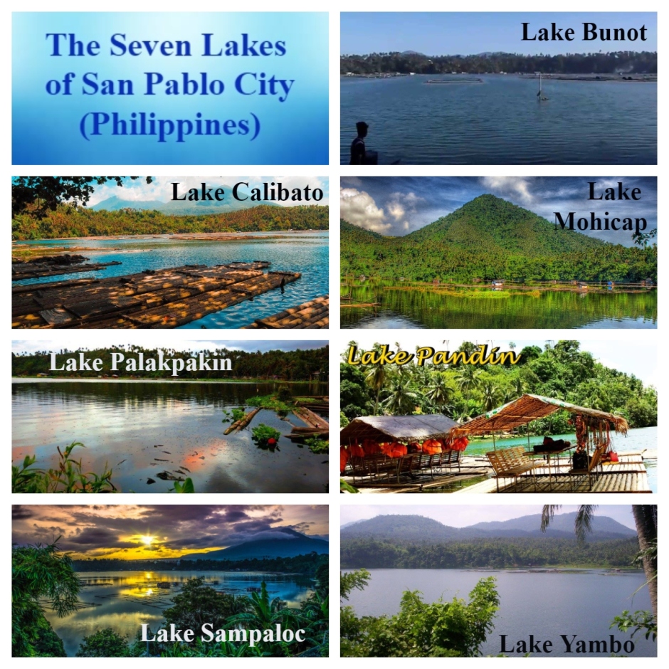
Dear readers, do you know that San Pablo City has seven lakes? Allow Tita S to tell you 12 facts about them.

1.The City of San Pablo1 is located in the province2 of Laguna3, in the Calabarzon4 region5, in the island group of Luzon6, Philippines.

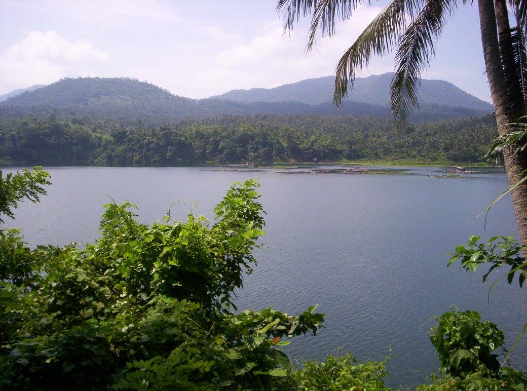
2. The 7 crater lakes are scattered all around the city. That is why it is called “The City of Seven Lakes”.

7-lakes-aerial-fb-1

Photo source: https://www.facebook.com/7-Lakes-of-San-Pablo-City-Laguna-356649184395237/photos/a.356650911061731/356651074395048 

3. The lakes are maars7, or low profile volcanic craters, located in the San Pablo Volcanic Field8. They are among the 200 small monogenetic9 volcanoes found along the Macolod Corridor10, a rift zone11 between Mount Makiling12 and Mount Banahaw13, which is part of the larger Southwestern Luzon Volcanic Field14.

The craters were formed by a unique process called phreatic eruption14 where shallow lava from Mount San Cristobal15 intersected groundwater which blew out (steam-heated eruption) the overlying rocks to form a circular and crater-like depression that eventually filled-up with rainwater. The varying depths of these lakes, which are from 7 m to 156 m, suggest a volcanic origin.

Mt San Cristobal-fb-2

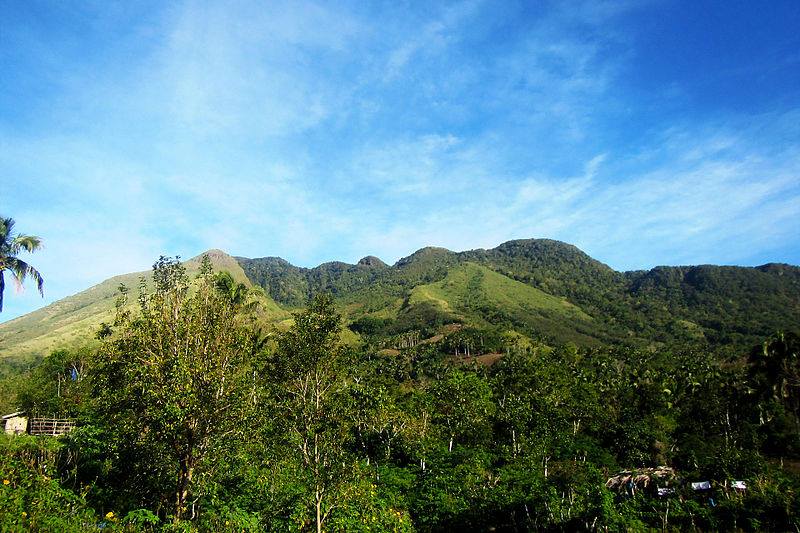
Mt. San Cristobal – Photo source: https://www.facebook.com/CityOfSevenLakes4000Philippines/photos/1150651761686320 

4. The first lake is Lake Bunot, a crater lake located in Barangay Concepcion, 4.5 km (2.8 mi) from the city proper. It has a normal surface area of 30.5 ha (75 acres), with a maximum depth of 23 m (75 ft). It is known for cultured tilapia in fishpens from where most of the residents derive their income.

Lake Bunot-FB-1

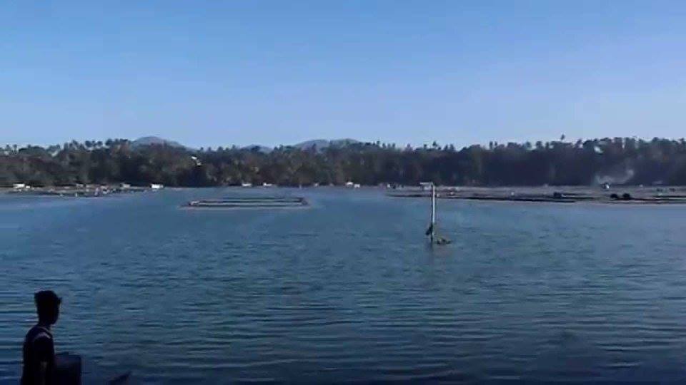
Lake Bunot – Photo source: https://www.facebook.com/CityOfSevenLakes4000Philippines/photos/a.1124214957663334/1124281297656700 post

There is a legend to the name of this lake – bunot (coconut husk). It is said that in the Spanish Era (1565 – 1898), some Spanish soldiers went to this lake for surveying purposes and inquired about the lake’s name from a man husking coconuts by the shore. The latter misunderstood, thinking the soldiers were asking for the name of the coconut husk in their dialect, and replied in Tagalog – bunot. The Spaniards left, believing that the name was Lake Bunot.

Lake Bunot is closest to Lake Sampaloc (the largest lake, at the center of the city; see fact 8) and is surrounded by houses.

5. The second lake is Lake Calibato or Lake Kalibato. This crater lake is located in Barangay Sto. Angel. It has an area of 42 hectares (100 acres), and an average depth of 156 m (511.811 ft).

Lake Calibato-FB-2

Lake Calibato – Photo source: https://www.facebook.com/CityOfSevenLakes4000Philippines/photos/1126268460791317 post

It is the deepest recorded lake among the 7 lakes. It has a maximum capacity of about 29,600 cubic meters (1,050,000 cu ft). Its supplies San Pablo City1 and nearby towns with abundant fish (like tilapia16) and aquatic plants.

You need to trek for about 15 minutes and pass through a small brook before you get to this lake.

It was told that there was a valley in the area of this lake that was allegedly inhabited by a fairy (diwata) who wanted to keep her realm free from the intrusion of mankind. She got angry when people built rocky pathways that criss-crossed her valley. She eventually caused a strong earthquake and a severe storm that transformed the valley into a lagoon. The following morning, the villagers were awed by the body of water and called it Lake Calibato – cali, taken from the corruption of the Spanish word called for “street”, and bato – the Tagalog word for “rock”.

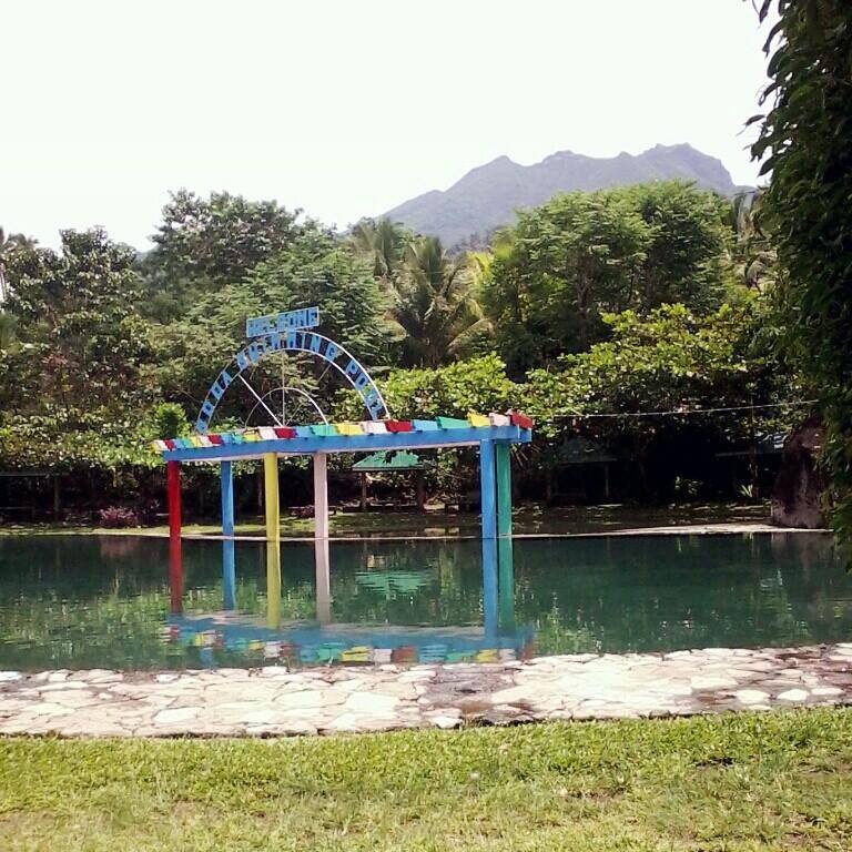
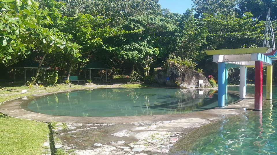
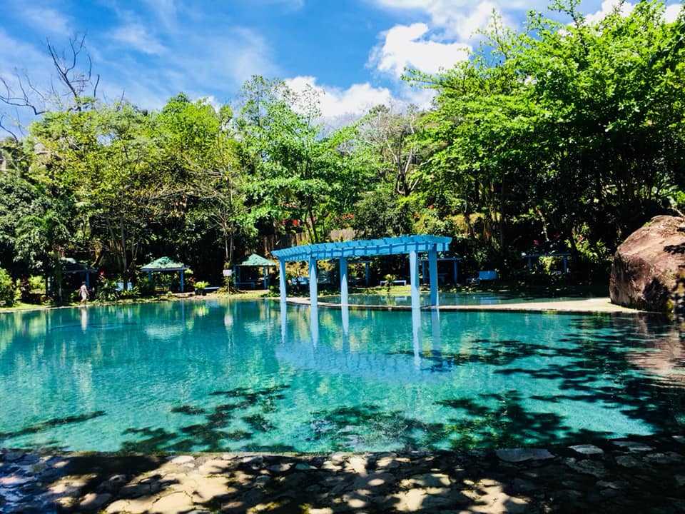
6. The third lake is Lake Mohikap, Lake Muhicap or Lake Mojicap. It has a surface area of 14.5 hectares (36 acres), a surface elevation of 80 meters (260 feet), a maximum length of 530 m (1,740 ft), and a maximum width of 490 m (1,610 ft). It is located in Barangay San Buenaventura and is one of the main suppliers of water in San Pablo City1. It is also a breeding area for shrimps, and is, likewise, a major source of tilapia16 for Metro Manila and suburbs.

Lake Mohikap-college-POST

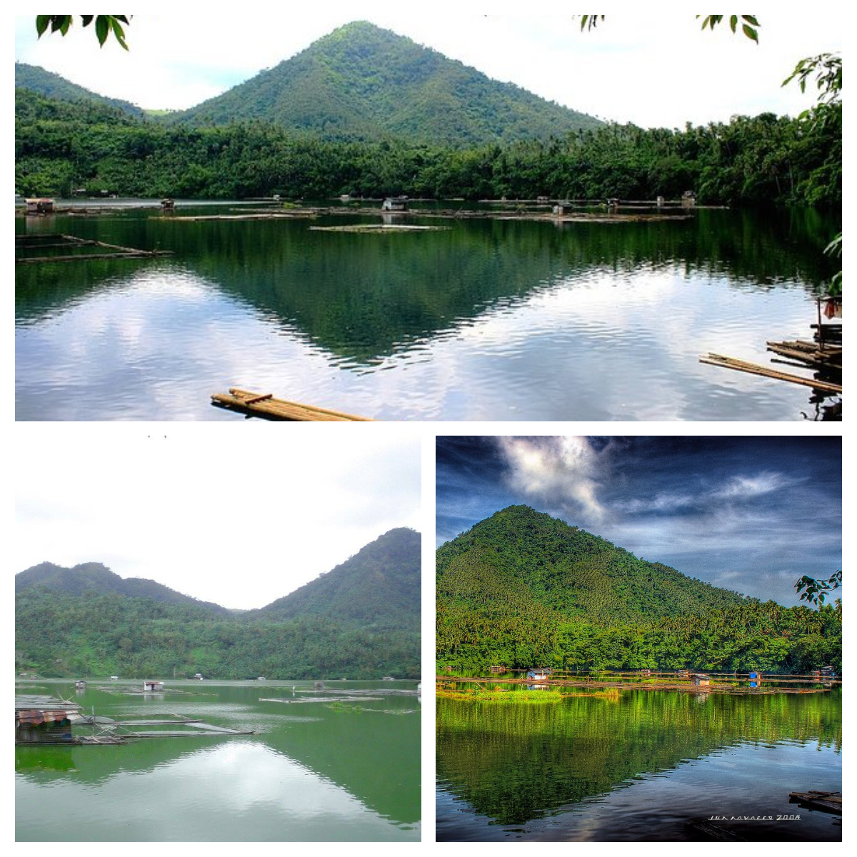
Lake Mohikap – Sources of photos: https://www.facebook.com/7-Lakes-of-San-Pablo-City-Laguna-356649184395237/photos/a.356653811061441/356653817728107 and https://www.facebook.com/CityOfSevenLakes4000Philippines/photos/ 

Legend goes that a couple had a very sickly daughter named Munica and they frequently prayed to God for her health. They promised to do anything if God granted their prayer on condition that Munica must not set foot on soil. She grew up to be healthy and very industrious. One day, she sewed a dress and a ball of thread fell on the ground. She tried to retrieve it, she fainted and fell. She sank with the entire neighborhood, and the lake formed. So, the lake was named after her industriousness in the local dialect, mahikap.

After paying PHP10 per person as entrance fee, you would have to descend 105-steps to see this lake, and you’ll also see mountains in the background. You can then rent a raft to get to the other side of the lake, and swim in shallower water. There are different sizes of bamboo rafts, from 1-2 persons (PHP300 total) to 7-12 persons (PHP120/pax)

You can also rent fishing equipment to catch fish like tilapia16 or catfish (hito). The fishing bamboo raft for 4 persons is PHP300 for 7 hrs.

7. The fourth lake is Lake Palakpakin, Lake Palacpaquin or Lake Palacpaquen. It is also located in Barangay San Buenaventura, just like Lake Mohikap. It has an area of 43 ha (110 acres) and a maximum depth of 7.5 m (25 ft).

Lake Palakpakin-FB-1

Lake Palakpakin – Photo source: https://www.facebook.com/CityOfSevenLakes4000Philippines/photos/a.1124214957663334/1124286890989474 post

It is the shallowest among all the 7 lakes. Residents, with houses around the lake, rely on income from fishpens and fish cages that grow cultured tilapia16 and silver carps.

There is a legend that a few kilometers from San Pablo City1 was a village with an ancient tree which had a hollow trunk, called Palakpak. On moonlit nights, villagers could see a beautiful red-haired lady washing her long hair using the hollow trunk as her wash basin. There was also a river nearby where a big fish appeared each night when the beautiful lady was around.

One day, a stranger came to the village and tried to solve the mystery of the lady and her fish. So, on a moonlit night, he waited for her and approached her. Suddenly, there was thunder and lightning. There was a severe earthquake, the river swelled, and formed a lake. From then on, the lake produced a large quantity of shrimps, which when cooked, turned red.  People called the lake Palakpakin, after the ancient tree, and the shrimps which gave the main source of livelihood to the local folks, they called Hipong Palakpakin or Palakpakin Shrimp.

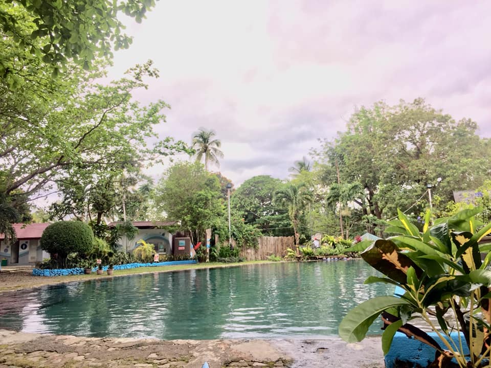
8. The fifth lake is Lake Sampaloc or Lake Sampalok. It is the largest of the 7 lakes and is located in the center of the city, i.e., behind the city hall, and is dotted with fishpens and small cottages built on stilts for tilapia16, big head carp, and several species of freshwater fish like catfish (hito), ayungin17 and mudfish (dalag), as well as shrimps.

Lake Sampaloc-collage-POST

Lake Sampaloc – Source of photos: https://www.facebook.com/CityOfSevenLakes4000Philippines/photos/

Its volcanic origin is attested by almost half of its depth which has a shallow depression at the bottom. It has a surface area of 104 ha (260 acres) with an average depth of 10 m (33 ft). It has a maximum width of 1.2 km (0.75 mi) and a maximum depth of 27 m (89 ft).

Legend goes that a tamarind (sampalok) tree once grew in the garden of a selfish, stingy, old woman. One day, an old man begged for some tamarind fruit as a cure for his ailing grandson but instead of helping him, the old woman released her ferocious dogs to drive him away. The old man was badly hurt, but he was actually a fairy (diwata) in disguise. When the old man departed, there was a thundering noise and rain, followed by the cracking of the earth. The entire orchard sank into a colossal pit which was immediately filled with water, which the villagers, henceforth, named the lake after the tree – sampaloc.

9. The sixth and seventh lakes are Lake Pandin and Lake Yambo, known as “Twin Lakes”. These lakes are located in Barangay San Lorenzo, and are separated only by a narrow strip of land.

Lake Pandin is said to be “the most pristine” of the 7 lakes and the best kept lake. It has an area of 20.5 ha, a maximum depth of 63 m, and a calculated volume of 6,600 m3 of water in storage. It has an abundant plant and fish life. This lake is also famous for swimming and lake tours.

Lake Pandin-collage-POST

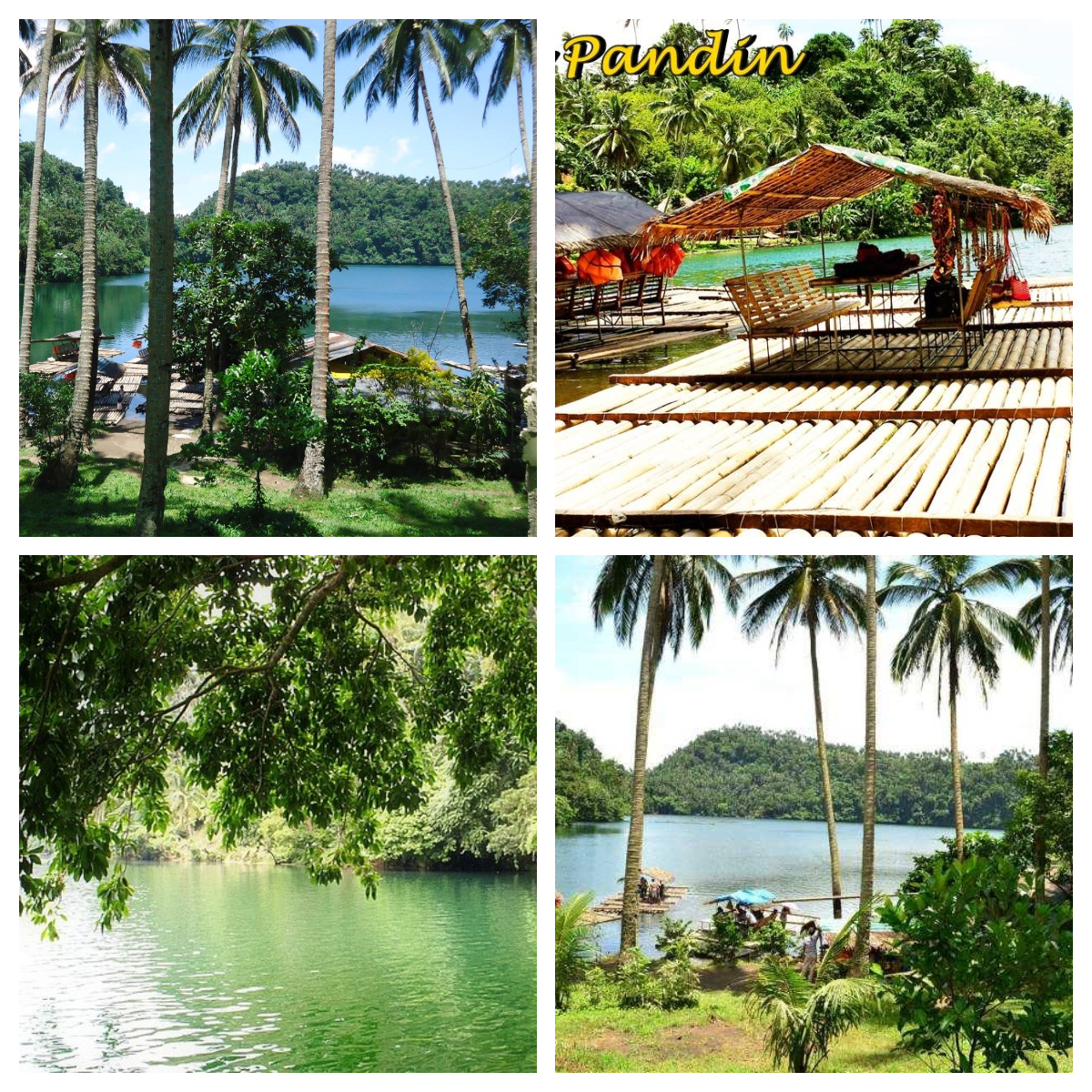
Lake Pandin – Source of photos: https://www.facebook.com/CityOfSevenLakes4000Philippines/photos/

You have to trek for about 20 minutes to reach this lake. You will pass by so many coconut trees and even a farm. When you reach the take-off point, register, pay PHP200 per person, and wait for your turn to ride an 8-person bamboo raft, good for a 2-hr ride. If you do not want to wait during your weekend or peak season visit, make a reservation.

While waiting, you can go around and buy some souvenirs, enjoy halo-halo18 or any snack or drink sold there, take pictures, and even find time to go to the rest room to prep for your two-hour ride. If there are less than 8 persons in your group, other visitors will be allowed to join your raft. Lunch (with bottled water) can be included in payment, for a total of PHP360. Life vests are provided. Fresh buko (coconut) is sold for PHP25.

The swimming area is shaded by a big tree with a swing. You are advised not to swim too far from the raft, and to always wear your life vest. Do not forget to have a picture taken while riding the swing.

Lake Yambo is a crater lake which has a surface area of 20.5 ha (51 acres) and an average depth of 63 m (207 ft). It is suitable for swimming, outings and picnics, just like its twin lake, Lake Pandin.

Lake Yambo-FB-1

Lake Yambo – Photo source: https://www.facebook.com/CityOfSevenLakes4000Philippines/photos/a.1124214957663334/1124280190990144

There is also a legend about these twin lakes, named after two lovers. A beautiful lady, named Pandin, was cursed not to step on the earth, otherwise, something terrible would befall her. Yambo, her ardent lover, did not know about the curse, and made her step on earth, after which there was a terrible noise, followed by the cracking grumble of the earth, and a heavy downpour, which eventually converted the area into two lakes, separated from each other by a bare strip of land.

You need to cross Lake Pandin and hike about 3-5 minutes to reach the vantage point of Lake Yambo.

10. In 2005, the Rotary Club of San Pablo City held a ceremony that officially opened the hiking trails that connect the 7 lakes of the city. I cannot find a map, or any detailed information, of the hiking trails but will definitely update this post once I access such information.

11. Do you know how to get to San Pablo from Metro Manila? You can take a bus heading to Lucena from the bus terminals of Ali Mall (in Cubao, Quezon City) or Buendia. The ride is about 2 1/2 hours and costs about PHP200. You can be dropped off at San Pablo Medical, from where you would take a tricycle to Sampaloc Lake for about PHP50. From Sampaloc Lake, you can negotiate and hire a tricycle to take you to the rest of the lakes for around PHP600. If you have a vehicle, just use your GPS.

12. It is so sad that these lakes are threatened by human intervention and exploitation, most especially Lake Sampaloc since it is located in the center of the city. However, a bay walk and leisure park were constructed around this lake. Said bay walk and park are protected and maintained by the city government through regular Friday cleanup.

Illegal fish pens and settlements as well as commercial infrastructures on the shores have proliferated on some of the lakes, and caused increased pollution.

The city government has addressed the problem of the entry of invasive species and pollution in the seven lakes since 1992, according to the City Environment and Natural Resources Officer Ramon de Roma.

Demolition and different ecological conservation were implemented by both government and non-government organizations in recent years. The city government has carried out its lake clean-up program which was initially funded by the Office of the President, enforced and sustained by the Fisheries and Aquatic Resources Management Council, and participated by multi-sectors groups.

The information was obtained from https://llda.gov.ph/seven-7-crater-lakes/, https://www.pna.gov.ph/articles/1060191, https://www.facebook.com/7-Lakes-of-San-Pablo-City-Laguna and the Wikipedia pages “Seven Lakes of San Pablo”19, “Lake Bunot”20, “Lake Calibato”21, “Lake Muhikap”22, Lake Palakpakin”23, “Lake Sampaloc”24, and “Lakes Pandin and Yambo”25.

So there you have it, nature lovers! A trip to San Pablo’s 7 lakes will surely uplift your spirits. Remember to reserve ahead of time, especially during weekends and peak season.

Here are some tips:

  1. Wear light clothes for short trekking.
  2. Bring swim wear and extra clothing.
  3. Fully charge your cellphones, cameras, GoPro, charger/s, etc.
  4. Visit this Facebook account: https://www.facebook.com/enchantinglakemohicap/?ref=page_internal. Get the contact number, and be sure to reserve, at least 3 days before your expected arrival so food can be part of your tour.  

Let us recap. You can go swimming and rafting. There are life vests for those who do not know how to swim.

You can rent a bike or a bicycle with a sidecar (for your companion, if any) and go from one lake to another. You can also rent fishing rods and catch your own fishes.

If you are lucky and visit early, you can also witness fishermen in action and buy their fresh catch. You can also camp around the lakes, just ask from the designated locations.

You can also trek or jog along the lakes to finish your exercise or 10,000-step goals for the day! Of course, you can try their lomi26, halo-halo18 and whatever else they sell during your visit. And, while you are in Laguna3, go to nearby attractions to maximize your stay there. You can visit http://www.sanpablocitygov.ph/ or the websites of the other nearby towns and the Laguna website for other attractions.

This is not a sponsored post. I just want my readers to know more about the Philippines.

Did you find this post informative? I would like to hear your comment/s regarding the 7 lakes of San Pablo, especially if you were able to see them.

See other interesting places through other posts in this category and other categories of SCapades, Pinoy Delights, and Smart Traveler – Now You Know, Short and Simple, and Say, Say, Say. Happy reading, and I hope that you will appreciate what I shared and some of the featured destinations will be part of your future travel plans!

Remember to share this post with your friends, follow me by clicking on the bottom right corner of your device, and do not forget to like this post. Thank you.

– – – – – – – – – – – – – – – – – – – – – – – – – –

The following terms are defined for interested readers, especially those with “Senior-Moments”, those not familiar with Filipino terms, and those too busy or lazy to Google such terms:

1The City of San Pablo is a first class city in the province2 of Laguna3, in the Calabarzon4 region5 of Luzon6, in the Philippines. It is one of the oldest cities in the country, and by land area, it is the largest in the province. It is called the “City of Seven Lakes”, referring to Lakes Bunot, Calibato, Muhikap, Palakpakin, Pandin, Sampaloc, and Yambo.

It was founded in 1586, chartered in 1647, and became a city on May 7, 1940. It has 80 barangays27.

The information was obtained from the Wikipedia page “San Pablo, Laguna.”28

2A province is the primary administrative and political division in the Philippines. It is the second-level administrative sub-division of a region5. There are 81 provinces (called lalawigan) in the Philippines. Each province is governed by an elected legislature called the Sangguniang Panlalawigan, and by an elected governor. Remember, a province in the Philippines is divided into cities and towns (called municipalities29), which in turn, are divided into barangays27, formerly called barrios. The information was obtained from Wikipedia page “Provinces of the Philippines.”30 

See a related post: Foreign Seniors Ask: WHAT ARE PROVINCES IN THE PHILIPPINES?

3Laguna is a province2 in the Calabarzon4 Region5 of the Philippines, located southeast of Metro Manila, north of the province of Batangas, west of the province of Quezon, south of the province of Rizal, and east of the province of Cavite. This is the 7th richest province in the country, and the third largest province in the region. It hugs the southern shores of Laguna de Bay, the largest lake in the country. It is composed of 24 municipalities29 and 6 cities. The provincial capital is the town of Santa Cruz since 1858, after Bay (1581-1688) and Pagsanjan (1688-1858). It is historically one of the first provinces in the Philippines to have been visited by Christian missionaries. Its main natural resources are its agriculture and fisheries, owing to its position near Laguna de Bay and the surrounding lowlands. The information was obtained from the Wikipedia page “Laguna (province)”.31

4Calabarzon, or Region IV-A, or Southern Tagalog Mainland, is a Philippine region5 located in the island group of Luzon6, with the city of Calamba as its regional center. CALABARZON is an acronym for this region’s five provinces2: CAvite, LAguna3, BAtangas, Rizal, QueZON. It is the most populated region in the country and the country’s second most densely populated region, after Metro Manila. This region is located south of the National Capital Region (NCR), bordered by the provinces of Aurora, Bulacan, and Metro Manila in the north, Manila Bay in the west, Tayabas Bay, and Sibuyan Sea in the south, and Lamon Bay, and the Bicol Region in the east. The information was obtained from the Wikipedia page “Calabarzon”32 and https://lga.gov.ph/region/region-iv-a.

5A region is an administrative division based on geographical, cultural and ethnological characteristics. Each region is further subdivided in provinces2, composed of cities and municipalities29 (or towns), which in turn, are divided into barangays27, formerly called barrios, according to Wikipedia page “Regions of the Philippines 33. 

See a related post: Foreign Seniors Ask: WHAT ARE THE REGIONS OF THE PHILIPPINES?

6Luzon is the largest and most populous island in the Philippines. It is ranked the 15th largest island in the world by land area, at 109,964.9 sq.km. (42,457.7 sq mi). It is the northern portion, among the three primary island groups in the Philippine archipelago, with Visayas at the center, and Mindanao at the southern part. It is the economic and political center of the country, with Manila as the capital city, and Quezon City as the country’s most populous city. It has a population of 53 million, as of 2015, representing 52.5% of the country’s total population, and the fourth most populous island in the world. The name Luzon comes from the Tagalog word lusong, a large wooden mortar used to de-husk rice. The information was obtained from the Wikipedia page “Luzon”.34

7A maar is a broad, low-relief volcanic crater caused by a phreatomagnetic eruption (an explosion which occurs when groundwater comes in contact with hot lava or magma). It characteristically fills with water to form a relatively shallow crater lake which may also be called a maar.

This shallow, flat-floored crater is a result of a violent expansion of magmatic gas or steam. It ranges in size from 60 to 8,000 m (200 – 26,250 ft) across, and from 10 to 200 m (33 – 656 ft) deep. It is commonly filled with water to form natural lakes. It usually has a low rim composed of a mixture of loose fragments of volcanic rocks.

The name comes from a Moselle Franconian dialect word used for the circular lakes of the Daun area of Germany.

The information was obtained from Wikipedia page “Maar.”35

8The San Pablo Volcanic Field, or the Laguna Volcanic Field, is an active volcanic field in the Philippines, located between Laguna de Bay, Mount Banahaw13 volcano complex and Mount Malepunyo36 range. It is part of the larger Southwestern Luzon Volcanic Field (SWLVF).

The field is composed of over 200 dormant and monogenetic9 maars7, crater lakes, scoria cones37, and stratovolcanoes38, the tallest of which is Mount Makiling12 at 1,090 m (3,580 ft) in elevation. The oldest sediment-filled maars are found in the town of Calauan in Laguna3, while the youngest maars are concentrated in San Pablo City1.

The information was obtained from Wikipedia page “Laguna Volcanic Field.”39

9Monogenetic means a maar9 or volcano erupted only once, as opposed to polygenetic, which means erupting repeatedly over a period of time, according to the Wikipedia page “Monogenetic volcanic field”40.

10The Macolod Corridor is an area, around 40 km wide, in southwestern Luzon6, with still active intense Quarternary volcanism which perpendicularly crosses Luzon in a NE-SW direction. The tectonic setting of this corridor is still somewhat questionable due to several, not yet understood, major structural elements affecting southwestern Luzon. Based on available information, it is believed that this corridor is a pull-apart zone formed by a diffuse system of NW-SE oriented shearing.41

11A rift zone is a feature of some volcanoes where a set of linear cracks (or rifts) develops in a volcanic edifice, typically forming into 2 or 3 well-defined regions along the flanks of the vent, believed to be primarily caused by internal and gravitational stresses generated by magma emplacement within and across various regions of the volcano.

It allows the intrusion of magmatic dykes to flow into a crack on the slope of the volcano which eventually solidifies as a sheet intrusion, either cutting across layers of rock or through a contiguous mass of rock. The accumulated lava of repeated eruptions from rift zones, along the endogenous growth created by magma intrusions causes these volcanoes to have an elongated shape.

The information was obtained from Wikipedia page “Rift zone.”42

12Mount Makiling, or Mount Maquiling, is an inactive stratovolcano38 located in the provinces2 of Laguna3 and Batangas, on the island group of Luzon6, Philippines. It rises to an elevation of 1,090 m (3,580 ft) above mean sea level, and is the highest feature of the Laguna Volcanic Field. This volcano has no recorded historic eruption, but volcanism is still evident through geothermal features like mud spring and hot springs.

Mount Makiling National Park is the first national park of the Philippines. It was established on February 23,1933 by Proclamation No. 552. It was then decommissioned as a national park on June 20,1963 by Republic Act. No. 3523, when it was transferred to the University of the Philippines Los Baños for use in forestry education and information. So, it is currently a state-owned forest reserve administered by the said university.

This mountain is sacred to many pilgrims, and is widely believed to be the home of Makiling, a goddess sent by the Tagalog43 supreme deity Bathala to aid mankind in the area. It is highly associated with the gifts of nature. Due to its importance, various sects have made the mountain an annual pilgrimage site. It was also declared as an ASEAN Heritage Park44 on September 25, 2013, with the title of “Mount Makiling Forest Reserve”.

The information was obtained from Wikipedia pages “Mount Makiling”45 and “Indigenous Philippine shrines and sacred grounds”46.

13Mount Banahaw is an active, three-peaked volcano located between the provinces2 of Laguna3 and Quezon, in the island of Luzon6, in the Philippines. It is the tallest mountain in the Calabarzon4 region5, with an elevation of 2,170 meters, so it is a favorite among mountain climbers. It is also considered a “sacred mountain” and pilgrims visit its sacred springs, caves, streams and boulders. The information was obtained from Wikipedia page “Mount Banahaw”.47

14A phreatomagmatic eruption is a volcanic eruption resulting from interaction between magma and water, according to the Wikipedia page “phreatomagmatic eruption”.48

15Mount San Cristobal is a potentially active volcano at the boundary of the provinces2 of Laguna3 and Quezon, on the island of Luzon6, Philippines. Its northern slope is bordered by city of San Pablo1, and its southern slope, by the municipality29 of Dolores. It has an elevation of 1,479 meters (4,820 feet) above mean sea level. The information was obtained from the Wikipedia page “Mount San Cristobal.”49

16Tilapia is a freshwater fish which inhabits shallow streams, ponds, rivers and lakes in temperate countries. In the Philippines, it is commonly called pla-pla, and several species of tilapia are commercially grown in major lakes and rivers like Laguna de Bay, Taal Lake and Lake Buhi. The information was obtained from the Wikipedia page “Tilapia”.50 

17Ayungin, bagaong, bigaong, bugaong, or silver perch, is a species of fish in the family of Terapontidae, the grunters. Leiopotherapon plumbeus, its genus-species name, is endemic to the Philippines and reaches 16 cm in maximum length. Would you believe that the male of the species is the one who guards and tends the eggs?

This fish is caught and consumed locally as food. It is considered to be one of the most delicious of the native freshwater fish in the country. However, it is now rare and expensive since its population was greatly declined due to overharvesting.

The information was obtained from the Wikipedia page “Leiopotherapon plumbeus”.51

18Halo-halo, or haluhalo, is a popular cold dessert or snack in the Philippines made of crushed ice, evaporated milk or condensed milk, and various ingredients like different kinds of sweetened beans, ube (purple yam), coconut strips, gulaman (agar), sago (tapioca pearls), pinipig (toasted, pounded immature grains of glutinous rice), topped with leche flan (Philippine creme caramel). Other ingredients used are fruit slices, sweetened langka (jackfruit), boiled and cubed taro, and soft cubed yams. For a special treat, a scoop of ice cream, preferably ube, tops this dessert. The information was obtained from the Wikipedia page “Halo-halo”.52

19“Seven Lakes of San Pablo,” accessed May 28, 2020, https://en.wikipedia.org/wiki/Seven_Lakes_of_San_Pablo

20“Lake Bunot,” accessed May 28, 2020, https://en.wikipedia.org/wiki/Lake_Bunot 

21“Lake Calibato,” accessed May 28, 2020, https://en.wikipedia.org/wiki/Lake_Calibato 

22“Lake Muhikap,” accessed May 28, 2020, https://en.wikipedia.org/wiki/Lake_Muhikap 

23“Lake Palakpakin,” accessed May 28, 2020, https://en.wikipedia.org/wiki/Lake_Palakpakin

24“Lake Sampaloc,” accessed May 28, 2020, https://en.wikipedia.org/wiki/Lake_Sampaloc 

25“Lakes Pandin and Yambo,” accessed May 28, 2020, https://en.wikipedia.org/wiki/Lakes_Pandin_and_Yambo 

26Lomi, or pancit lomi, is a Filipino dish made with a variety of thick fresh egg noodles, sauteed thinly sliced pork (or chicken) and pork liver, soup stock, chopped cabbage, seasoned as desired, and thickened with a slurry. Just before serving steaming hot, in individual bowls, a beaten egg is added while continuously stirring to complete this dish. Toppings are added like slices of kikiam53, fish balls, cooked shrimp, meatballs, chives, stir-fried pork or chicken, and coarsely ground roasted garlic. A spicy condiment can be provided, consisting of a mixture of soy sauce, calamansi (Philippine lime) juice and crushed fresh red chili peppers. Some people request a small amount of finely chopped fresh red onions for extra pungency. The information was obtained from the Wikipedia page “Lomi”.54

27A barangay is the smallest administrative division in the Philippines, headed by a barangay captain, aided by a Sangguniang Barangay (Barangay Council). It is the native Filipino term for a district or village. It was formerly called a barrio. In a metropolitan area, a barangay is an inner city neighborhood, a suburb, or a suburban neighborhood. The word barangay originated from the term balangay, a kind of boat used by a group of Austronesian people who migrated to the Philippines. A number of barangays grouped together is called a district. The information was obtained from Wikipedia page “Barangay.”55

28“San Pablo, Laguna,” accessed April 2, 2018, https://en.wikipedia.org/wiki/San_Pablo,_Laguna

29A municipality is a small, single urban administrative division, or local government unit (LGU)56, in the Philippines which has corporate status and powers of self-government or jurisdiction as granted by law. It is a unit under a province2, subdivided into barangays27, and is called town, or bayan. In the Philippines, a municipality is headed by a mayor, a vice mayor and members of the Sangguniang Bayan (legislative branch). The information was obtained from Wikipedia page “Municipalities of the Philippines.”57

30“Provinces of the Philippines,” accessed July 17, 2018, https://en.wikipedia.org/wiki/Provinces_of_the_Philippines

31“Laguna (province),” accessed April 2, 2018, https://en.wikipedia.org/wiki/Laguna_(province)

32“Calabarzon,” accessed March 2, 2020, https://en.wikipedia.org/wiki/Calabarzon

33“Regions of the Philippines,” accessed July 17, 2018, https://en.wikipedia.org/wiki/Regions_of_the_Philippines

34“Luzon,” accessed April 2, 2018, https://en.wikipedia.org/wiki/Luzon

35“Maar,” accessed May 28, 2020, https://en.wikipedia.org/wiki/Maar  

36Mount Malepunyo is an extinct volcano which is the highest peak (among 3) of the Malepunyo Range, located in Barangay27 Talisay, Lipa City, in the province2 of Batangas, Philippines. It is 1.002 m (3,287 ft) above mean sea level by the ridge of its caldera. The information was obtained from Wikipedia page “Malepunyo Mountain Range.”58

37A cinder cone, scoria cone, or scoria mound, is a small, steep-sided volcanic cone built of loose pyroclastic59 fragments. As gas-charged lava is blown violently into the air, it breaks into small fragments that solidify and fall either as volcanic clinkers, cinders, volcanic ash, or scoria60 around the vent to form a cone that often is beautifully symmetrical, with slopes between 30 and 40°, and a nearly circular ground plan. It has a basal diameter of 800 meters (2,600 ft.) and range from 250-2,500 meters (820-8,200 ft.). It rarely rises more than 50-350 meters (160-1,150 ft.) or so above its surroundings. It typically has a bowl-shaped crater at the summit, with a diameter ranging between 50 and 600 meters (160 and 1,970 ft.). It is usually active for very brief periods of time before becoming inactive. The information was obtained from the Wikipedia page “Volcanic cone”.61

38A stratovolcano is a conical volcano built up by many layers of hardened ash, lava, pumice and tephra62. It has a steep profile with a summit crater and periodic intervals of explosive and effusive eruptions, but some may have collapsed summit craters called calderas. Its lava flow typically cools and hardens before spreading far due to high viscosity, but extensive felsic lava63 flows may travel up to 15 km (9.3 miles). It is sometimes called a composite volcano because of its composite stratified structure built up from sequential outpourings of erupted materials. Examples are Mount Pinatubo (also in the Philippines), Krakatoa (Indonesia) Mount St. Helens (USA) and Mount Vesuvius (Italy). The information was obtained from the Wikipedia page “Stratovolcano”.64

39“Laguna Volcanic Field,” accessed May 28, 2020, https://en.wikipedia.org/wiki/Laguna_Volcanic_Field 

40“Monogenetic volcanic field,” accessed May 28, 2020, https://en.wikipedia.org/wiki/Monogenetic_volcanic_field 

41https://www.sciencedirect.com/science/article/abs/pii/004019519090420D 

42“Rift zone,” accessed May 28, 2020, https://en.wikipedia.org/wiki/Rift_zone

43Tagalog refers to the second largest ethnolinguistic group in the Philippines, after the Visayan people, numbering around 30 million, with most of them inhabiting Metro Manila, the Calabarzon4 region5 in southern Luzon6, the islands of Marinduque and Mindoro in Mimaropa, as well as a plurality in the provinces2 of Aurora, Bataan, Bulacan, Nueva Ecija and Zambales in Central Luzon. The information was obtained from Wikipedia page “Tagalog (people).”65

44An ASEAN Heritage Park is a selected protected area in the ASEAN region which is known for its unique biodiversity and ecosystems, wilderness and outstanding values in scenic, cultural, educational, research, recreational and tourism. This was started by ASEAN on November 29, 1984, and as of February 18, 2021, there are 50 such parks. The information was obtained from Wikipedia page “ASEAN Heritage Parks.”66 See https://en.wikipedia.org/wiki/ASEAN_Heritage_Parks for the complete list. 

45“Mount Makiling,” accessed May 28, 2020, https://en.wikipedia.org/wiki/Mount_Makiling 

46“Indigenous Philippine shrines and sacred grounds,” accessed May 28, 2020, https://en.wikipedia.org/wiki/Indigenous_Philippine_shrines_and_sacred_grounds 

47“Mount Banahaw”, accessed March 1, 2018, https://en.wikipedia.org/wiki/Mount_Banahaw

48“Phreatomagmatic eruption,” accessed May 28, 2020, https://en.wikipedia.org/wiki/Phreatomagmatic_eruption 

49“Mount San Cristobal,” accessed March 29, 2020, https://en.wikipedia.org/wiki/Mount_San_Cristobal

50“Tilapia,” accessed December 12, 2018, https://en.m.wikipedia.org/wiki/Tilapia

51“Leiopotherapon plumbeus,” accessed May 28, 2020, https://en.wikipedia.org/wiki/Leiopotherapon_plumbeus 

52“Halo-halo,” accessed May 28, 2020, https://en.wikipedia.org/wiki/Halo-halo

53Kikiam, a popular street food in the Philippines, is a crispy mini meat-roll, sliced diagonally, skewered and served with your choice of sauces: spicy, sweet, or sweet-sour. It is made of seasoned ground pork and minced shrimp, or ground fish (turned into a paste), steamed, then deep-fried. It is peddled in wooden carts along streets with high traffic, along with street food like fish balls and squid balls.

54“Lomi,” accessed May 28, 2020, https://en.wikipedia.org/wiki/Lomi 

55“Barangay,” accessed April 2, 2018, https://en.wikipedia.org/wiki/Barangay

56A local government unit (LGU) in the Philippines is divided into 3 levels: provinces2, cities and municipalities29; and, barangays27, according to Wikipedia page “Local government in the Philippines”.67

57“Municipalities of the Philippines,” accessed April 2, 2018, https://en.wikipedia.org/wiki/Municipalities_of_the_Philippines

58“Malepunyo Mountain Range,” accessed May 28, 2020, https://en.wikipedia.org/wiki/Malepunyo_Mountain_Range 

59A pyroclastic flow, pyroclastic density current, or pyroclastic cloud, is a fast-moving current of hot gas and volcanic matter (collectively known as tephra62) that flows along the ground away from a volcano at velocities of 100 km/h (62 mph) on average but is capable of reaching speeds up to 700 km/h (430 mph), with temperatures reaching 1,000°C (1,830°F). It is the most deadly of all volcanic hazards, and is produced as a result of certain explosive eruptions. It normally touches the ground and hurtles downhill, or spreads laterally under gravity. The information was obtained from the Wikipedia page “Pyroclastic flow”.68

60Scoria is a highly vesicular, dark colored (brown, black, or purplish red) volcanic rock that may or may not contain crystals (phebocrysts). The information was obtained from the Wikipedia page “Scoria”.69 

61“Volcanic cone,” accessed May 28, 2020, https://en.wikipedia.org/wiki/Volcanic_cone

62Tephra is a fragmental material produced by a volcanic eruption, regardless of composition, fragment size, or emplacement mechanism. The information was obtained from the Wikipedia page “Tephra”.70

63Felsic lavas are thick and gooey lava, not as hot as mafic lava, high in silica and volatiles, and resist flowing. Their high volatile content makes them potentially highly explosive. Most are extremely viscous and typically fragment as they extrude.

64“Stratovolcano,” accessed May 28, 2020, https://en.wikipedia.org/wiki/Stratovolcano

65“Tagalog people,” accessed January 15, 2018, https://en.wikipedia.org/wiki/Tagalog_people

66“ASEAN Heritage Parks,” accessed May 28, 2020, https://en.wikipedia.org/wiki/ASEAN_Heritage_Parks 

67“Local government in the Philippines,” accessed April 2, 2018, https://en.wikipedia.org/wiki/Local_government_in_the_Philippines

68“Pyroclastic flow,” accessed May 28, 2020, https://en.wikipedia.org/wiki/Pyroclastic_flow

69“Scoria,” accessed May 28, 2020, https://en.wikipedia.org/wiki/Scoria

70“Tephra,” accessed May 28, 2020, https://en.wikipedia.org/wiki/Tephra

BURA SODA WATER PARK (Catarman, Camiguin, Philippines)

Dear readers, do you know that there is a unique water park in Camiguin? Allow Tita S to tell you.

Bura Soda Water Park is a resort located in Barangay1 Bura, in the municipality2 of Catarman3, in the island-province4 of Camiguin5, in the Northern Mindanao6 region7 of the Philippines.

Bura-Soda-Water-Park-8-fb-ok

Photo source: https://www.facebook.com/sodanature/photos/866378486809303 

It is less than a 30-minute drive from Mambajao, the provincial capital.

You know what makes it unique? It is the only soda water pool in the Philippines! Volcanic springs provide this unique flowing water.

Bura-Soda-Water-Park-1-fb

Photo source: https://www.facebook.com/sodanature/photos/a.657519087695245/657870670993420 

It is open daily, from 7:00 AM – 10PM.

Better check if they are closed for cleaning, usually on Wednesdays.

You need to pay an entrance fee. The regular rate is PHP50, with a discounted rate for seniors and children below 10-years-old. Better check if these rates are still current.  

Bura-Soda-Water-Park-2-fb

Photo source: https://www.facebook.com/sodanature/photos/a.657519087695245/657519091028578 

There is continuous flowing soda water in which any guest can swim (do not drink). However, there is a designated place and faucet for you to taste the natural soda water.  

There are signs which state the benefits of soda water: it is good for hydrating, and makes you feel full thereby decreasing your food consumption. It reduces osteoporosis, decreases cardiovascular risks, and lowers blood pressure.

The water is clean and cold in the pools, and regularly maintained.

Bura-Soda-Water-Park-3-fb-ok

Photo source: https://www.facebook.com/sodanature/photos/3855744634539325 

The adult pool’s deepest part is 5 feet deep, while the kiddie pool is 3 feet deep.

Bura-Soda-Water-Park-7-fb-2 pools-ok

Photo source: https://www.facebook.com/sodanature/photos/866378520142633

A lifeguard is on duty.

The resort offers picnic sheds for rent at PHP75.

Bura-Soda-Water-Park-6-fb-ok

Photo source: https://www.facebook.com/sodanature/photos/3855744017872720 

Barbecuing is permitted and there are designated places. Snacks and drinks are sold in a small store.

There is also a playground for kids, and kids-at-heart, to enjoy.

A souvenir shop outside, but near this resort, provides opportunity for buying pasalubong8 before you leave this place.

When in Camiguin5, always remember the provincial policy “Leave No Trace” so dispose of all trash properly during your stay there.

The information was obtained from https://www.lanzonescabana.com/bura-soda-water-swimming-pool/, https://www.touristlink.com/philippines/bura-soda-water-pool/overview.html, https://www.mustseespots.com/philippines/bura-soda-water-swimming-pool, and https://www.cebusite.com/news/2430103/bura-soda-water-swimming-pool-a-place-with-super-clean-water.    

Tita S has not been to this unique water park, but it will definitely be part of her Camiguin5 travel bucket list. This province has so many attractions to see and appreciate!

This is not a sponsored post. I just want my readers to know more about the Philippines.

The photo featured in the cover picture-collage was obtained from https://www.facebook.com/sodanature/photos/3855744017872720 

Did you find this post informative? I would like to hear your comment/s regarding Bura Soda Water Park, especially if you were able to visit it already.

See other interesting places through other posts in this category and other categories of SCapades, Pinoy Delights, and Smart Travelers – Foreign Travelers Ask, Now You Know, and Say, Say, Say. Happy reading, and I hope that you will appreciate what I shared and some of the featured destinations will be part of your future travel plans!

Remember to share this post with your Facebook friends, and to follow me by clicking on the bottom right corner of your device. And, do not forget to like this post. Thank you.  

– – – – – – – – – – – – – – – – – – – – – – – – – –

The following terms are defined for interested readers, especially those with “Senior-Moments”, those not familiar with Filipino terms, and those too busy or lazy to Google such terms:

1A barangay in the Philippines is the smallest administrative division in the Philippines, headed by a barangay captain, aided by a Sangguniang Barangay (Barangay Council). It is the native Filipino term for a village. It was formerly called a barrio. In a metropolitan area, a barangay is an inner city neighborhood, a suburb, or a suburban neighborhood. The word barangay originated from the term balangay, a kind of boat used by a group of Austronesian people who migrated to the Philippines. A number of barangays grouped together is called a district. The information was obtained from Wikipedia page “Barangay.”9

2A municipality is a small, single urban administrative division, or local government unit (LGU), in the Philippines which has corporate status and powers of self-government or jurisdiction as granted by law. It is a unit under a province4, subdivided into barangays1, and is locally called bayan. In the Philippines, a municipality is headed by a mayor, a vice mayor, and members of the Sangguniang Bayan (legislative branch). It can enact local policies and laws, enforce them, and govern its jurisdictions. It can enter into contracts and other transactions through its elected and appointed officials and can tax as well. It enforces all local and national laws. There are almost 1,500 municipalities in the Philippines. The information was obtained from Wikipedia page “Municipalities of the Philippines.”10

3Catarman is a municipality2 in the island-province4 of Camiguin5, in the Northern Mindanao6 region7 of the Philippines. It has an area of 53.75 sq.km. (20.75 sqm.) and 14 barangays1. It is known for the following attractions: Sunken Cemetery; Old Church Ruins or Gui-ob Ruins; the 25-m high Tuasan Falls, the Bura Soda Water Park, and the Santo Niño Cold Spring. The information was obtained from Wikipedia page “Catarman, Camiguin.”11

4A province is the primary administrative and political division in the Philippines. It is the second-level administrative sub-division of a region7. There are 81 provinces (called lalawigan) in the Philippines. Each province is governed by an elected legislature called the Sangguniang Panlalawigan, and by an elected governor. Remember, a province in the Philippines is divided into cities and towns (called municipalities2), which in turn, are divided into barangays1, formerly called barrios. The information was obtained from Wikipedia page “Provinces of the Philippines.”12 

See a related post: Foreign Seniors Ask: WHAT ARE PROVINCES IN THE PHILIPPINES?

5Camiguin is a pearl-shaped island-province4 in the Bohol Sea, in the Northern Mindanao6 region7 of the Philippines. Aside from the main island, this province also includes a few other surrounding minor islets like: White Island, about 5 km (3.1 mi) west of the capital-municipality2 of Mambajao (the provincial capital), and, Mantigue Island, about 14 km (8.7 mi) south of Mambajao.

It is the second smallest island in the Philippines, in both land area (238 sq.km. or 92 sqm) and population, next to Batanes, an archipelagic province3 in the northernmost part of the country. It was founded in 1565 and became a province on June 18, 1966.

The information was obtained from Wikipedia page “Camiguin.”13

6Northern Mindanao, or Region 10, is an administrative region7 in the north-central part of Mindanao14, in southern Philippines. It has a total land area of 2,049,602 hectares (5,064,680 acres), with more than 60% classified as forest land. Its waters are rich in marine life. It comprises 5 provinces4: Bukidnon, Camiguin5, Lanao del Norte, Misamis Occidental, and Misamis Oriental. The regional center is the city of Cagayan de Oro.

It is the 8th most populous region in the Philippines, and the 2nd in Mindanao (after Davao Region (Region 11). The vast majority of the region’s inhabitants descended from migrants from Bohol and Cebu.

The information was obtained from the Wikipedia page “Northern Mindanao”.15

7A region is an administrative division based on geographical, cultural and ethnological characteristics. Each region is further subdivided in provinces4, composed of cities and municipalities2 (or towns), which in turn, are divided into barangays1, formerly called barrios, according to Wikipedia page “Regions of the Philippines 16. 

See a related post: Foreign Seniors Ask: WHAT ARE THE REGIONS OF THE PHILIPPINES?

8Pasalubong is the Filipino term referring to both the tradition of giving gifts or souvenirs, as well as to the actual gift itself, from a destination visited by a Filipino, to family and friends upon one’s return home.

9“Barangay,” accessed December 30, 2018, https://en.m.wikipedia.org/wiki/Barangay

10“Municipalities of the Philippines,” accessed January 29, 2019,  https://en.wikipedia.org/wiki/Municipalities_of_the_Philippines

11“Catarman, Camiguin,” accessed February 2, 2021, https://en.wikipedia.org/wiki/Catarman,_Camiguin  

12“Provinces of the Philippines,” accessed May 29, 2019, https://en.wikipedia.org/wiki/Provinces_of_the-Philippines

13“Camiguin,” accessed February 2, 2021, https://en.wikipedia.org/wiki/Camiguin 

14Mindanao is one of the 3 major geographical divisions of the Philippines. It is the second largest island of the country and covers 6 administrative regions7: Caraga, Davao, Northern Mindanao6, SOCCSKSARGEN, Zamboanga Peninsula, and the Bangsamoro Autonomous Region in Muslim Mindanao (BARMM). It is composed of 22 provinces4 and 33 cities (27 provinces and 33 cities, if associated islands are included). The information was obtained from Wikipedia page “Mindanao.”17 Mindanao is located in the southern part of the country; the 2 other geographical divisions of the Philippines are Luzon (in the northern part) and Visayas (the middle part).

15“Northern Mindanao,” accessed November 3, 2020,

https://en.wikipedia.org/wiki/Northern_Mindanao

16“Regions of the Philippines,” accessed July 17, 2018, https://en.wikipedia.org/wiki/Regions_of_the_Philippines

17“Mindanao,” accessed April 2, 2018, https://en.wikipedia.org/wiki/Mindanao

RAISIN BREAD (Baguio Country Club, Baguio City, Philippines)

Hello, Filipino readers! What do you look forward to eating, and/or buying as pasalubong when you go to Baguio? A buffet breakfast at The Manor? Fresh strawberries, vegetables, peanut brittle? Strawberry taho at Burnham Park? Strawberry jam and walis tambo from the wet market? Vizco’s cake? Woodcarvings? How about the yummy goodies from Good Shepherd, like my favorite, their ube jam? Is that all?

Wait, you forgot another favorite of Tita S! You have to go to the Baguio Country Club (BCC) to order lots of bread, especially their raisin bread, and that is what this post is all about, during this pandemic when you have a bread craving and cannot go to Baguio!

Did you know that the BCC raisin bread recipe was an old home recipe of Mrs. Kate Reed Crosby, a former General Manager of the Club? It is made from imported California raisins, and just the right amount of cinnamon. The bread was originally served for merienda to some club members who wanted something to eat with their coffee. It was an instant hit and became a staple, traditional loaf, for coffee drinkers in the Club.

BCC-Raisin-Bread-3-fb-history-ok

Photo source: https://www.facebook.com/baguiocountryclubph/photos/a.258931563756/10151664025878757/ 

It is best enjoyed with hot freshly brewed coffee. And you know what? The breads are baked the night before their delivery day to be sure of their freshness (check the production date mark). And the raisins, they are not dry at all but pleasantly juicy, and a treat even for those who are not fond of raisins. It is like you are back in the BCC!

Yes, dear readers in Metro Manila, and those not from Region 1, you can now enjoy this iconic raisin bread for breakfast during a rainy pandemic day!

BCC-Raisin-Bread-10-fb-up close-ok

Photo source: https://www.facebook.com/FindGoodBaguioFoods/photos/baguio-country-club-raisin-bread-as-one-of-the-desserts-/1361283393891602/ 

BCC-Raisin-Bread-5-fb-ok

Photo source: https://www.facebook.com/baguiocountryclubph/photos/a.258931563756/10154140032373757/ 

BCC-Raisin-Bread-8-fb-wrapped-ok

Raisin Bread on display, December 16, 2020 – Photo source: https://www.facebook.com/baguiocountryclubph/photos/pcb.10158202814503757/10158202811633757 

BCC-Raisin-Bread-9-fb-SM-Baguio-ok

Available at the 2nd Level, Villa Cordillera kiosk, SM City Baguio, May 2017 – Photo source: https://www.facebook.com/smcitybaguio/photos/1374071219302973 

The management of the BCC decided to reach out to their patrons who cannot visit their outlet amidst the pandemic, for members and/or guests to fulfill their bread and pastry fix –

* breads – raisin, banana, carrot, cheese, French, multigrain, sovital, whole wheat

* others – cheese roll, cinnamon roll (small/big), coffee crunch, ensaymada, ham and cheese croissant, mamon, blueberry/chocolate muffin, pandesal (10 pcs.), soft roll (12 pcs.)

BCC-Raisin-Bread-1-fb

Baguio Country Club goodie list and prices, as of February 23, 2021 – Photo source: https://www.facebook.com/bccdeliversmanila/photos/a.103811701852774/120477563519521 

There are 4 ways to get hold of their breads and pastries:

1.First, if you are a Club member and can go to the BCC, you can directly buy from the BCC outlet. You can call their landline (074) 619 2050.

BCC-Raisin-Bread-2-fb-BCC-facade-ok

Photo source: https://www.facebook.com/baguiocountryclubph/photos/a.10150589806153757/10158244730958757

2. For those who have access to SM City Baguio, proceed to the Villa Cordillera kiosk, Second Level, Lower Ground, Sunset Terraces, for take-out, from 10AM – 6PM.

BCC-Raisin-Bread-6-fb-SM0Baguio-2020-May-18-ok

Available at SM City Baguio, May 2017 – Photo source: https://www.facebook.com/baguiocountryclubph/photos/a.258931563756/10157656855458757/ 

3. For those who have access to SM City Central Urdaneta, proceed to the second level for the BCC kiosk.

BCC-Raisin-Bread-7-fb-SM-Urdaneta-2020-Dec-16-ok

Available at SM City Urdaneta Central, Dec. 2020 – Photo source: https://www.facebook.com/baguiocountryclubph/photos/pcb.10158202814503757/10158202768568757/ 

4. BCC Delivers – This is an ordering process using a combination of communication platforms:

* For Metro Manila –

BCC-Raisin-Bread-12-fb-deliver-Manila-ok

How to Order for Metro Manila Residents, as of April 22, 2021 – Photo source: https://thebaguiocountryclub.com/bcc-delivers-metro-manila/ 

* For Baguio and Benguet –

BCC-Raisin-Bread-11-fb-deliver-Bag-Benguet-ok

How to Order for Baguio-Benguet Residents, as of April 22, 2021 – Photo source: https://thebaguiocountryclub.com/bcc-delivers-baguio-benguet/ 

So, what are you waiting for? Bread fix, check!

This is not a sponsored post. I just want my readers to know how they can again enjoy the BCC treats, all from the comfort and safety of their homes!

The information was obtained from https://thebaguiocountryclub.com/baguio-country-club-counter/,

The photo featured in the cover picture-collage was obtained from https://www.facebook.com/smcitybaguio/photos/1374071219302973 

https://mb.com.ph/2020/10/12/icymi-baguio-country-club-is-now-delivering-its-famous-raisin-bread-to-manila/, https://www.clickthecity.com/food-drink/article/59283/baguio-country-club-raisin-bread-and-banana-bread-is-now-available-in-metro-manila/, https://www.spot.ph/eatdrink/the-latest-eat-drink/82542/how-to-get-baguio-country-clubs-raisin-bread-delivered-in-manila-a3284-20200617, https://thebaguiocountryclub.com,

https://www.facebook.com/baguiocountryclubph, and https://www.facebook.com/smcitybaguio.

Did you find this post informative? I would like to hear your comment/s regarding _____.

See other interesting posts in this category (Pinoy Delights) and other categories – SCapades and Smart Travelers – Foreign Travelers Ask, Now You Know, and Say, Say, Say. Happy reading, and I hope that you will appreciate what I shared and some of the featured destinations will be part of your future travel plans! 

Remember to share this post with your Facebook friends, follow me by clicking on the bottom right corner of your device, and do not forget to like this post. Thank you.

TIBOK-TIBOK: THE MILK PUDDING OF PAMPANGA

Dear Foreign Seniors, Tita S will share with you an interesting dessert from the Philippines.

1.Tibok-tibok, or carabao milk pudding, is an authentic Filipino dessert pudding made primarily from carabao milk and galapong (ground glutinous rice soaked overnight), and topped with latik (browned coconut cream curds). It is also served as a snack.

Tibok-tibok-1-fb

Tibok-tibok, Susie’s Cuisine, Pampanga – Photo source: https://www.facebook.com/susiescuisineph/photos/2975444322669380 

2. It originated in the province1 of Pampanga2, in the Central Luzon3 region4, in the island group of Luzon5, Philippines. It is also popular in the province of Cagayan6.

Tibok-tibok-2-fb-2-sliced-ok

Sliced tibok-tibok, Susie’s Cuisine, Pampanga – Photo source: https://www.facebook.com/susiescuisineph/photos/a.1735440103336481/1758804994333325 

3. The carabao milk is traditionally mixed with a small amount of galapong and flavored with a small amount of white sugar and dayap (key lime) zest.

Whole fat cow’s milk can replace carabao milk in areas where the latter is not available. Just add a pinch of salt to the former since the latter has a slightly salty taste. Remember, carabao’s milk has 100% more fat content than cow’s milk, so it makes a thicker and creamier pudding.

Rice flour or corn starch can substitute for galapong. If you do not have rice flour, you can make it at home by grinding rice using a food processor until powdery. If you use corn starch, the result is a firmer and less silky textured tibok-tibok.

The mixture is simmered at low heat, while stirring continuously until the mixture thickens. It is immediately poured into a greased flat banana leaf-lined pan and allowed to cool and completely set.

Tibok-tibok-4-wsite-Cabalen

Tibok-tibok, Cabalen – Photo source: https://www.cabalen.ph/desserts 

Tibok-tibok-5-wsite-Cabalen-mais-ok

Tibok Mais, a variation with corn at Cabalen – Photo source: https://www.cabalen.ph/desserts 

It is easier to cut when this pudding has already cooled and set. It is usually cut into square or diamond-shaped slices. You can also refrigerate it to be fully set, before generously adding the latik as topping. It can be served cold or at room temperature.

Tibok-tibok-3-fb-Nathaniel's

Sliced tibok-tibok, Nathaniel’s – Photo source: https://d.facebook.com/NathanielsBakeshop/photos/a.10150298239407022/10155689781382022/?type=3&__tn__=EH-R 

It can be stored in airtight containers covered with a plastic film to prevent it from drying out. Be sure to refrigerate it, not later than 2 hours after cooling, or it might spoil. It can keep for about 3 days in the refrigerator.

View this 3:18 video: https://www.youtube.com/watch?v=H1usRvs3tfg.

4. This dessert is creamy white, has a soft, smooth, jelly-like texture, and has a creamy, delicately sweet, and slightly salty flavor.

Tibok-tibok-2-fb-2-ok

Tibok-tibok, Susie’s Cuisine – Photo source: https://www.facebook.com/susiescuisineph/posts/tibok-tibok-is-all-about-love-its-the-sound-your-heart-makes-masarap-din-itong-k/2006522896228199/ 

5. Tibok-tibok literally means “[like a] heartbeat”. Why? During its preparation, when the mixture gets to be reduced to a firm consistency, the bubbles barely break the surface and seem to be pulsating. When this happens, the dish is done!

6. It is very similar to another Filipino snack or dessert, the maja blanca, which is a coconut pudding, basically made of coconut milk, cornstarch and sugar. Thus, some call tibok-tibok as the Maja Blanca of Pampanga2.

See my post about this Filipino delight: SAVORING MAJA BLANCA

Maja Blanca-2-wiki

Maja Blanca – Photo source: kawalingpinoy, CC BY-SA 4.0, created 22 February 2017, https://en.wikipedia.org/wiki/Maja_blanca#/media/File:Majablanca.jpg

The information was obtained from https://www.yummy.ph/lessons/cooking/pampanga-tibok-tibok-a00249-20181215  and the Wikipedia page “Tibok-tibok”7.

The pictures featured in the cover picture-collage were obtained from https://www.cabalen.ph/desserts.

This is not a sponsored post. I just want my readers to know more about Philippine delicacies.

Did you find this post informative? I would like to hear your comment/s regarding tibok-tibok.  

See other interesting posts in this category (Pinoy Delights) and other categories – SCapades and Smart Travelers – Foreign Travelers Ask, Now You Know, and Say, Say, Say. Happy reading, and I hope that you will appreciate what I shared and some of the featured destinations will be part of your future travel plans! 

Remember to share this post with your Facebook friends, and to follow me by clicking on the bottom right corner of your device.  And, do not forget to like this post. Thank you.  

– – – – – – – – – – – – – – – – – – – – – – – – – –

The following terms are defined for interested readers, especially those with “Senior-Moments”, those not familiar with Filipino terms, and those too busy or lazy to Google such terms:

1A province is the primary administrative and political division in the Philippines. It is the second-level administrative sub-division of a region4. There are 81 provinces (called lalawigan) in the Philippines. Each province is governed by an elected legislature called the Sangguniang Panlalawigan, and by an elected governor. Remember, a province in the Philippines is divided into cities and towns, which in turn, are divided into barangays8, formerly called barrios. The information was obtained from Wikipedia page “Provinces of the Philippines.”

See a related post: Foreign Seniors Ask: WHAT ARE PROVINCES IN THE PHILIPPINES?

2Pampanga is a province1 lying on the northern shore of Manila Bay, in the Central Luzon3 region4 (Region III) of the Philippines. It is bordered by the provinces of Tarlac to the north, Zambales to the west, Bataan to the southwest, Nueva Ecija to the northeast, Bulacan to the east, and Manila Bay to the central south. Its capital is the City of San Fernando. The information was obtained from the Wikipedia page “Pampanga”.10

This province is known as the Culinary Capital of the Philippines because of its delicious cuisine that features dishes like: sisig, tocino, nasing biringyi (chicken saffron rice), morcon, menudo, caldereta, estofado, embotido, asado, lengua, lechon, chicharon, afritada, bringhi (paella). The information was obtained from the Wikipedia page “Kapampangan cuisine”.11

3Region III, called the Central Luzon Region, is a Philippine region4 located in the island group of Luzon5, with 7 provinces: Aurora, Bataan, Bulacan, Nueva Ecija, Pampanga2, Tarlac and Zambales. It has three cities, all located in the province of Pampanga: Angeles (a 1st class12 highly urbanized city13), Mabalacat (a 3rd class14 component city15) and San Fernando (a 1st class component city and the regional center). It is dubbed as “The Rice Granary of the Philippines” because this region contains the largest plain in the country and produces most of the country’s rice supply. The information was obtained from the Wikipedia page “Central Luzon”.16

4A region is the first-order administrative division in the Philippines. There are 17 regions in the Philippines, based on geographical, cultural and ethnological characteristics. It is further subdivided in provinces1, composed of cities and towns, which in turn, are divided into barangays8 (district or village). The information was obtained from the Wikipedia page “Regions of the Philippines.”17 

See a related post: Foreign Seniors Ask: WHAT ARE THE REGIONS OF THE PHILIPPINES?

5Luzon is the largest and most populous island in the Philippines. It is ranked the 15th largest island in the world by land area, at 109,964.9 sq.km. (42,457.7 sq mi). It is the northern portion, among the three primary island groups in the Philippine archipelago, with Visayas at the center, and Mindanao at the southern part. It is the economic and political center of the country, with Manila as the capital city, and Quezon City as the country’s most populous city. It has a population of 53 million, as of 2015, representing 52.5% of the country’s total population, and the fourth most populous island in the world. The name Luzon comes from the Tagalog word lusong, a large wooden mortar used to de-husk rice. The information was obtained from the Wikipedia page “Luzon”.18

6Cagayan is a province1 located in the Cagayan Valley region, in the northeastern tip of Luzon5, in the Philippines. It has an area of 9,295.75 sq. km. (3,589.11 sq. mi.)

It was founded on June 29, 1583 and was one of the early provinces that existed during the Spanish colonial period (1565-1898). Its capital is Tuguegarao. The information was obtained from the Wikipedia page “Cagayan”.19 

7“Tibok-tibok,” accessed January 29, 2019, https://en.wikipedia.org/wiki/Tibok-tibok 

8A barangay is the smallest administrative division in the Philippines. It is headed by a barangay captain, aided by a Sangguniang Barangay (Barangay Council). It is the native Filipino term for a village. It was formerly called a barrio. In a metropolitan area, a barangay is an inner-city neighborhood, a suburb, or a suburban neighborhood. The word barangay originated from the term “balangay”, a kind of boat used by a group of Austronesian people who migrated to the Philippines. A number of barangays grouped together is called a district. The information was obtained from Wikipedia page “Barangay.”20

9“Provinces of the Philippines,” accessed July 17, 2018, https://en.wikipedia.org/wiki/Provinces_of_the_Philippines

10“Pampanga” accessed April 2, 2018, https://en.wikipedia.org/wiki/Pampanga

11“Kakampangan cuisine” accessed April 2, 2018, https://en.wikipedia.org/wiki/Kapampangan_cuisine

12A first class city in the Philippines has an average annual income for a 4-year period of at least 500 million pesos, according to the Wikipedia page “Cities of the Philippines.”21

13A highly urbanized city is a type of city in the Philippines with a minimum population of 200,000 as certified by the Philippine Statistics Authority (PSA), and with the latest annual income of at least 50 million pesos. There are currently 33 such cities in the Philippines. The information was obtained from the Wikipedia page “Cities of the Philippines.”21

See a related post: Foreign Seniors Ask: HOW MANY CITIES ARE THERE IN THE PHILIPPINES?

14A third class city in the Philippines has an average annual income for a 4-year period of 240 million, but less than 320 million pesos, according to the Wikipedia page “Cities of the Philippines.”21.

15A component city is a type of city in the Philippines which does not meet the requirements of a highly urbanized city13. It is under the jurisdiction of a province1. If such a city is located along the boundaries of 2 or more provinces, it shall be considered part of the province of which it used to be a town (locally called a municipality). The information was obtained from Wikipedia page “Cities of the Philippines.”21

16“Central Luzon,” accessed April 2, 2018, https://en.wikipedia.org/wiki/Central_Luzon

17“Regions of the Philippines,” accessed July 17, 2018, https://en.wikipedia.org/wiki/Regions_of_the_Philippines

18“Luzon,” accessed April 2, 2018, https://en.wikipedia.org/wiki/Luzon

19“Cagayan,” accessed January 29, 2019, https://en.wikipedia.org/wiki/Cagayan

20“Barangay,” accessed January 29, 2019, https://en.wikipedia.org/wiki/Barangay

21“Cities of the Philippines,” accessed March 17, 2018, https://en.wikipedia.org/wiki/Cities_of_the_Philippines

BANGUI WIND FARM (Bangui, Ilocos Norte, Philippines)

Dear foreign readers, do you know that there are six operational wind farms in the Philippines? Allow Tita S to tell you about one (of three) which is located in Ilocos Norte.

Yes, there are 3 wind farms in this province. Ilocos Norte1 is blessed with regular North Westerly winds because of its strategic location in the northwestern tip of the Luzon island group at the northern part of the Philippines.

Anyway, let me tell you about Bangui Wind Farm. It is a wind farm located in the town of Bangui2, in the province3 of Ilocos Norte1, in the Ilocos4 Region5, in the northwestern part of the island group of Luzon, at the northernmost part of the Philippine archipelago. 

BANGUI-WIND-FARM-1-wiki

Photo source: Jesstine Co, own work, CC BY-SA 4.0, created 10 June 2017, https://en.wikipedia.org/wiki/Ilocos_Norte#/media/File:Bangui_Windmill.jpg 

It is the Philippines’ oldest wind farm and the first power-generating wind farm in Southeast Asia. The undeveloped and uninhabited area is devoid of trees and vegetation and does not pose any threat to the environment.

BANGUI-WIND-FARM-5-wiki

Photo source: Iandelgado, own work, CC BY-SA 3.0, created 24 September 2010, https://en.wikipedia.org/wiki/Bangui,_Ilocos_Norte#/media/File:Bangui_windmills.jpg 

This wind farm is more accessible and popular than the two other wind farms in the province – the Burgos Wind Farm in the town of Burgos, and Caparispisan Wind Farm in the town of Pagudpod.

It uses 20 units of 70-m (230 ft) high Vestas6 V82 1.65 MW wind turbines, arranged in a single row, stretching along a 9-km (5.6 mi) shoreline off Bangui Bay, facing the West Philippine Sea.

BANGUI-WIND-FARM-4-fb

Photo source: https://www.facebook.com/TourIlocosNorte/photos/3560424750700751 

The wind turbines are dubbed as Ilocos Norte’s giant electric fans. Each wind turbine has 3 vertically-oriented rotor blades on top of a high tubular tower, with a 6-m diameter base. This wind generating equipment is expected to last for 21 years.

This wind farm project started with an aid grant of US$48 million from the Danish government to the province of Ilocos Norte1 in 1998.

It was inaugurated on June 18, 2005, and was commissioned on June 20, 2005. It is owned by the NorthWind Power Development Corporation which developed, and now maintains and operates, the wind farm. The Danish firm Vestas Wind Systems supplied the wind turbine-generator units (WTGs) for the site, similar to those found in Denmark. Since then, this wind farm project has become a popular tourist attraction of the province.

This project was ratified by the NorthWind Power Development Corporation and the International Bank for Reconstruction and Development through the World Bank Prototype Carbon Fund. It is the first project in the Philippines to have the Emissions Reduction Purchase Agreement (ERPA) under the Clean Development Mechanism. It is also the first Philippine recipient of the Carbon Emission Reduction Certificates (CER’s) from the Executive Board of the United Nations Framework Convention on Climate Change.

The first phase, which amounted to US$23 million, consisted of 15 70-m (230 ft) high, on-shore wind turbines, each with a maximum production capacity of 1.65 MW of electric power, for a total of 24.75 MW. They were spaced 326 m (1,070 ft) apart, with 41 m (135 ft) long blades, with a rotor diameter of 82 m (269 ft) and a wind-swept area of 5,281 sqm (56,840 sq ft).

These wind turbines face Bangui Bay where the prevailing northwesterly and southwesterly winds blow inland. Their location along the shore is optimal due to a lack of windbreaks and limited terrain roughness. Phase I was completed on May 7, 2005, and generated 24.74 MW.

Phase II added 5 more of the same wind turbines and was completed on August 2008, for a total 20 operational wind turbines, a total maximum capacity of 33 MW, transmitting 5.7 km (3.5 mi) to an electrical substation in Laoag City. Connected to the Luzon Grid, this wind farm supplied 40% of Ilocos Norte’s electricity needs, through the Ilocos Norte Electric Cooperative (INEC).

In 2018, this wind farm expanded and was able to provide 50%, or 33 MW, of Ilocos Norte’s electricity. As of September 2020, Bangui Wind Farm had a total of 26 wind turbines, capable of producing electricity up to a maximum total generating capacity of 41 MW.

The Bangui Wind Farm was also Southeast Asia’s largest wind farm when it opened in 2005 until 2014, when nearby Burgos Wind Farm opened, with 150 MW.

The wind power produced in this farm is bought by INEC, which covers 23 municipalities and Laoag City. INEC purchases the electricity created through a 20-year Energy Sales Agreement (ESA) at a discount to the typical rate, and those savings are passed on to consumers.

This wind farm estimates that almost 57,000 tons of CO2e (tons of carbon dioxide equivalent) of greenhouse gases will be reduced per year for the duration of the project. That is 1.2 million tons of Carbon Dioxide! Talk about sustainable and renewable energy! This gives Ilocos Norte one of the lowest carbon emission footprints in Asia, when combined with hydro-electric power generation.

Would you believe that the shores where this wind farm is located is a precious place where the critically endangered hawksbill sea turtles lay their eggs, up to 150 eggs in a nest at a time? Local environmental officials have been monitoring the stretch of the shoreline for sea turtle nesting areas. The provincial fishery division of the provincial government and local government units have included in their information campaigns the conservation and protection of this endangered species. NorthWind Power Development Corporation which holds the lease within the foreshore area has commissioned people to look after the nests during nesting season to protect them from predators and poachers.

So, how do you get to Bangui to see this wind farm? From Metro Manila, you can fly to Laoag City’s International Airport, about 1 hour and 20 minutes. From there, a group can hire a van and head straight to Bangui2.

Those on a budget can ride a bus from Metro Manila to Laoag, but the ride is about 10-12 hours, so why not take the evening trip? Next, take another bus from Laoag to Bangui town proper for about 1 1/2 hours, then hire a tricycle to the Bangui Wind Farm and nearby attractions, for about PHP300.

You can also use your own vehicle to drive from Metro Manila to Bangui2, at a travel time of 11 – 14 hours depending on traffic and stopovers. Just follow the Pan-Philippine Highway, and pass through the towns of Bacarra, Pasuquin and Burgos. From the latter, look out for directional signs leading to the wind farm, and Tita S is sure that eventually, the wind turbines will be very visible from the highway. Make a left turn a few meters after passing the Burgos Wind Farm. Drive straight ahead until you reach Estrells’ Place Resort, then turn right.

You also have the option to join a 4-D 3-N package tour of Ilocos Norte1, just google options.

By the way, there is no entrance fee to visit this clean and green wind farm. You can walk from one turbine to another and take as many pictures as you want. They say that if you do not want to walk, you may opt to ride around with a horse for only PHP100.

It is recommended that you visit this wind farm early morning or nearing sunset so it will not be too hot for you, and have great sunrise or sunset shots, along the shores of the Bangui Bay.

It would be best to wear closed footwear to avoid collecting sand after your walk. If it is a windy day, better protect your legs by wearing pants for possible small stones blown by the wind. Protect your face, if need be, too.

There is a restaurant where you can enjoy coffee and snacks while looking at the wind turbines’ rotating blades.

I was told that there are a couple of air-conditioned huts where you can stay overnight if you want some alone-time for some peace and quiet away from the city, or just meditate, synced with the circular motion of the wind turbines’ blades.

This wind farm also boosted local farmers to sell onions and garlic in roadside stalls, and small entrepreneurs to sell souvenirs like wooden replicas of the wind turbines, pin wheels, keychains, etc.

The information was obtained from http://www.pagudpud-ilocos.com/bangui-windmills.html,

https://primer.com.ph/travel/2017/03/07/bangui-wind-farm/, https://www.facebook.com/pages/Bangui-Wind-Farm/370956566282893,

http://alternergy.com/33mw-bangui-bay-wind-farm/,

https://www.ph.arteliagroup.com/Services/bangui-bay-wind-farm/,

https://app.philippines.travel/experiences/bangui-windmill-farm,

https://newsinfo.inquirer.net/563477/ilocos-wind-farm-hosts-endangered-turtles-too?fbclid=IwAR1yiA4aLqKsTGpLTWFZfMYaTnj90erq7hGDOy4O4EraAMLTi38A7cgYUOE and the Wikipedia pages “Bangui Wind Farm”7, “Wind power in the Philippines”8, “Wind power by country”9, and “List of power plants in the Philippines”10.

Your Ilocos Norte1 trip will not be complete without going to Bangui Wind Farm. So, better include it in your itinerary. See footnote 1 below for the popular tourist attractions of this province that you can include in your Ilocos Norte travel bucket list.

I have not been to this wind farm but have visited Ilocos Norte1 during my college days. So, the next time I visit this province, I will include the 3 winds farms and tell you about them.

This is not a sponsored post. I just want my readers to know more about the Philippines.

Did you find this post informative? I would like to hear your comment/s regarding Bangui Wind Farm, especially if you were able to see it.

See other interesting places through other posts in this category and other categories of SCapades, Pinoy Delights, and Smart Traveler – Now You Know, Short and Simple, and Say, Say, Say. Happy reading, and I hope that you will appreciate what I shared and some of the featured destinations will be part of your future travel plans!

Remember to share this post with your friends, follow me by clicking on the bottom right corner of your device, and do not forget to like this post. Thank you.

– – – – – – – – – – – – – – – – – – – – – – – – – –

The following terms are defined for interested readers, especially those with “Senior-Moments”, those not familiar with Filipino terms, and those too busy or lazy to Google such terms:

1Ilocos Norte is a province3 in the northern tip of the Ilocos4 region5, in the northwestern part of the island group of Luzon, at the northernmost part of the Philippine archipelago. It covers a total area of 3,467.89 sq. km. (1,338.96 sq. mi.). It is bordered by the Luzon Strait to the north, the West Philippine Sea to the west, Ilocos Sur to the southwest, Cagayan to the northeast, Apayao to the east, and Abra to the southeast. It was founded in 1818 and its capital is Laoag City. It consists of 21 towns and 2 component cities11 (Batac and Laoag).

This province boasts of the following popular tourist attractions: Fort Ilocandia Resort Casino; the Paoay Lake golf course designed by Gary Player for President Ferdinand Marcos in 1977; the La Paz Sand Dunes for sandboarding and 4×4 vehicle riding; the Malacañang of the North which was the family 2-storey mansion-residence of the family of President Marcos when he was president and is now a presidential museum; the 1892 Cape Bojeador Lighthouse where early galleons used to sail by during the Spanish colonial period (1565 – 1898) in the Philippines; the 3 wind farms (in the towns of Bangui. Burgos and Caparispisan); Kapurpurawan Burgos Rock Formation for its creamy white limestone formations sculpted by wind, waves and sedimentation over thousands of years; the 1612 45-m (150 ft) Sinking Bell of Laoag, sinking 1-inch a year because it is so heavy and was built on sandy formations; St. Augustine Church or Paoay Church, a UNESCO World Heritage Site under the collective group of Baroque Churches of the Philippines in 1993, and a national Cultural Treasure; Museo Ilocos Norte, a museum which has a large collection of Ilocano, Igorot and Itneg traditional clothing and artifacts and special exhibits; Batac Museum or Marcos Museum dedicated to President Marcos; and Saud Beach in the town of Pagudpud.

See my post about Saud Beach: SAUD BEACH (Pagudpud, Ilocos Norte, Philippines) 

The information was obtained from http://www.pagudpud-ilocos.com/laoag-sinking-bell-tower.html, https://guidetothephilippines.ph/articles/what-to-experience/laoag-tourist-spots, https://en.wikipedia.org/wiki/Paoay_Church and the Wikipedia page “Ilocos Norte.”12

2Bangui is a town (called a municipality in the Philippines) in the province3 of Ilocos Norte1, in the Ilocos4 Region5 of the Philippines. It has a total land area of 112.98 sq. km. (43.62 sq. mi.), with 14 barangays13.

It became a popular tourist destination because of the Bangui Wind Farm, along Bangui Bay. Unfortunately, you cannot swim in the latter because of its deepness and water currents, so just appreciate its beauty from the Bangui Bay Viewing Building.

Other tourist destinations include: Abang Falls, Baruyen Dam, Bolo River (or Caramuangen River), Sentinella Hill, Suacan Spring, and the municipal plaza.

The information was obtained from the Wikipedia page “Bangui, Ilocos Norte”.14

3A province is the primary administrative and political division in the Philippines. It is the second-level administrative sub-division of a region5. There are 81 provinces (called lalawigan) in the Philippines. Each province is governed by an elected legislature called the Sangguniang Panlalawigan, and by an elected governor. Remember, a province in the Philippines is divided into cities and towns (called municipalities), which in turn, are divided into barangays13, formerly called barrios. The information was obtained from Wikipedia page “Provinces of the Philippines.”15 

See a related post: Foreign Seniors Ask: WHAT ARE PROVINCES IN THE PHILIPPINES?

4The Ilocos Region, or Region 1, is an administrative region5 of the Philippines which occupies the northwestern section of the Luzon group of islands in the northernmost part of the Philippine archipelago. It is bordered by the South China Sea to the west, Cagayan Valley Region to the northeast and southeast, Cordillera Administrative Region to the east, and the Central Luzon Region to the south.

It has a total area of 13,012.6 sq. km. (5,024.19 sq. mi). It comprises 4 provinces3 – Ilocos Norte1, Ilocos Sur, la Union and Pangasinan, and a total of 116 towns. Its regional center is the city of San Fernando (in La Union). It has 1 independent city16 – Dagupan City, and 8 component cities11 – Alaminos, Batac, Candon, Laoag, San Carlos, San Fernando, Urdaneta and Vigan. Most residents speak Ilocano.

The information was obtained from Wikipedia page “Ilocos Region.”17

5A region is an administrative division based on geographical, cultural and ethnological characteristics. Each region is further subdivided in provinces3, composed of cities and towns (called municipalities), which in turn, are divided into barangays13, formerly called barrios, according to Wikipedia page “Regions of the Philippines 18. 

See a related post: Foreign Seniors Ask: WHAT ARE THE REGIONS OF THE PHILIPPINES?

6Vestas Wind Systems A/S is a Danish manufacturer, seller, installer and servicer of wind turbines, with headquarters in the city of Aarhus. It was founded in 1945 by Peder Hansen. It operates manufacturing plants in Denmark, Australia, Brazil, China, Germany, India, Italy, the Netherlands, Norway, Poland, Romania, Spain, Sweden, Taiwan, the United Kingdom, and the USA.

As of 2013, it is the largest wine turbine company in the world. It has installed over 66,000 wnd turbines for a capacity of 100 GW, in over 80 countries, on 5 continents, as of 2019.

The information was obtained from Wikipedia page “Vestas.”19

7“Bangui Wind Farm,” accessed February 20, 2021, https://en.wikipedia.org/wiki/Bangui_Wind_Farm 

8“Wind Power in the Philippines,” accessed February 20, 2021, https://en.wikipedia.org/wiki/Wind_power_in_the_Philippines 

9“Wind power by country,” accessed February 20, 2021, https://en.wikipedia.org/wiki/Wind_power_by_country 

10“List of power plants in the Philippines,” accessed February 20, 2021, https://en.wikipedia.org/wiki/List_of_power_plants_in_the_Philippines 

11A component city is a type of city in the Philippines which does not meet the requirements of a highly urbanized city (see footnote 12). It is under the jurisdiction of a province3. If such a city is located along the boundaries of 2 or more provinces, it shall be considered part of the province of which it used to be a municipality (town). The information was obtained from Wikipedia page “List of cities in the Philippines.”20

12“Ilocos Norte,” accessed February 20, 2021, https://en.wikipedia.org/wiki/Ilocos_Norte 

13A barangay in the Philippines is the smallest administrative division in the Philippines, headed by a barangay captain, aided by a Sangguniang Barangay (Barangay Council). It is the native Filipino term for a village. It was formerly called a barrio. In a metropolitan area, a barangay is an inner city neighborhood, a suburb, or a suburban neighborhood. The word barangay originated from the term balangay, a kind of boat used by a group of Austronesian people who migrated to the Philippines. A number of barangays grouped together is called a district. The information was obtained from Wikipedia page “Barangay.”21

14“Bangui, Ilocos Norte,” accessed February 20, 2021, https://en.wikipedia.org/wiki/Bangui,_Ilocos_Norte 

15“Provinces of the Philippines,” accessed May 29, 2019, https://en.wikipedia.org/wiki/Provinces_of_the-Philippines

16An independent city in the Philippines has 3 major characteristics: its Sangguniang Panlungsod (the city’s legislative council composed of councilors, with the vice mayor as presiding officer) legislation is no longer subject to review by any province’s Sangguniang Panlalawigan (the provincial council/board; the provincial legislative branch); it stops sharing its tax revenue with any province; and, the President of the Philippines exercises direct supervising authority over the city government.

It can be classified as either:

* highly urbanized city – a city with a minimum population of 200,000 inhabitants, as certified by the Philippine Statistics Authority, and with the latest annual income of at least PHP50 million (USD1 million), as certified by the City Treasurer; or,

* independent component city – a city which is independent from the province in which it is geographically located, and residents cannot vote for provincial officials; there are only 5 – Cotabato, Dagupan, Naga (Camarines Sur), Ormoc and Santiago.

The information was obtained from Wikipedia page “List of cities in the Philippines.”20

See a related post: Foreign Seniors Ask: HOW MANY CITIES ARE THERE IN THE PHILIPPINES?

17“Ilocos Region,” accessed February 20, 2021, https://en.wikipedia.org/wiki/Ilocos_Region 

18“Regions of the Philippines,” accessed July 17, 2018, https://en.wikipedia.org/wiki/Regions_of_the_Philippines

19“Vestas,” accessed February 20, 2021, https://en.wikipedia.org/wiki/Vestas

20“List of cities in the Philippines,” accessed April 2, 2018,

https://en.wikipedia.org/wiki/List_of_cities_in_the_Philippines

21“Barangay,” accessed December 30, 2018, https://en.m.wikipedia.org/wiki/Barangay

SAUD BEACH (Pagudpud, Ilocos Norte, Philippines)

Dear foreign readers, do you know that there is a beach in the Philippines that, in April 2021, was included in the 25 Most Beautiful Beaches in the World by Travel+Leisure? No, it is not Boracay, nor any Palawan, Visayan, or Mindanao beach. It is up north in the Philippines, proving that world-class Philippine beaches are all over our country!

Want to know what the Philippine beach is, and the rest of the beaches in the list? Allow Tita S to tell you.

1.Saud Beach is located in Barangay1 Saud, in the municipality2 of Pagudpud3, the province4 of Ilocos Norte5, Ilocos6 region7, in the island of Luzon8, Philippines.

Saud beach-fb-1

Saud Beach, “The Crown Jewel of Pagudpud” – Photo source: https://www.facebook.com/page/197186436974903/search/?q=saud%20beach

2. It was listed among the 25 Most Beautiful Beaches in the World9 by Travel+Leisure, a New York-based travel magazine, in its post dated April 12, 2021.

The magazine described the beach this way: “If you’re searching for Southeast Asian beach bliss, super-mellow Saud Beach on the island of Luzon8 is a sure thing. Its white sand pitches gradually into the clear-as-glass water, like a real-world example of a zero-entry swimming pool. Swim in the peaceful waves, lunch under a thatch-roof cabana under the palms, or hire an outrigger for excursions on the water.”10

Watch this 3:38 video: https://www.youtube.com/watch?v=8MyoN69qPK8https://www.youtube.com/watch?v=8MyoN69qPK8

3. Imagine, it is the only beach in the Philippines to make it to the 2021 list, along with the famous beaches in Brazil, Hawaii, Greece, Seychelles, and Italy, among others!

Saud beach-wsite-1

Photo source: http://www.pagudpud-ilocos.com/saud-beach.html

It is also one of the 3 Southeast Asian beaches included in the list, with the other two being Bai Dam Trau in the Con Dao Islands of Vietnam, and Railay West, in Krabi, Thailand.

BAI DAM TRAU BEACH-fb-1

Bai Dam Trau, Vietnam – Photo source: https://www.facebook.com/condaodiscover/photos/

Railay West Beach-Thailand-wiki-1

Railay West, Thailand – Photo source: kailerna, own work, CC BY-SA 3.0, created 13 January 2012, https://en.wikipedia.org/wiki/Railay_Beach#/media/File:Railay_Beach_5.jpg

On second thought, why not! Pagudpud3 is dubbed as the “Paradise of the North” because of its pristine coastline and Saud Beach as the “Boracay of the North” because of its powdery white sand which is similar to Boracay11.

However, unlike Boracay, Saud beach has tranquil waters and quiet and underdeveloped surroundings. It is not as crowded and is very peaceful, perfect for those who want to relax, swim, surf, snorkel or scuba-dive, without too many tourists and establishments.12

See footnote 9 for the 25 beaches included in the prestigious list.

4. About half of Saud beach is private so you can book a beach resort for a beachfront treat. The other half of the beach is public/municipal, you just have to pay a minimal amount for your beach-stay, and you can stay in a homestay or lodging property in town, or even in Laoag (2 hours from Pagudpud). For more information, you can contact the Pagudpud Municipal Tourism Office at the Municipal Hall, at telephone number 0920-228-6569.

5. Interested to visit Saud beach when it will be again safe to do so? Now, here is how to get there:

* The fastest way is to ride a plane from Manila to Laoag, using Philippine Airlines and Cebu Pacific, among others. It would cost about PHP7,500 to almost PHP10,000.

* If you have the time and are on a budget, go by land. Those from Metro Manila can ride a bus like Farinas, Florida, Maria de Leon, Partas, or Victory Liner, costing about PHP700 to almost PHP1,000, depending on the type of bus, with 9 hours travel time to Laoag. There are bus companies that offer air-conditioned sleeper buses with comfortable reclining seats and built-in toilets.

From Laoag, ride a bus, jeep or van to Pagudpud, for less than 2 hours, for a road distance of 73 km. It would cost around PHP75-100 for a bus, For a group, you will be more comfortable to negotiate for a rented van.

* If you want to drive your own vehicle, it would take around 10-12 hours from Metro Manila to Pagudpud, depending on traffic and stopovers.

The information was obtained from the following sources: Anne Olivia Bauso, https://www.travelandleisure.com/trip-ideas/beach-vacations/most-beautiful-beaches-in-the-world; Joyce Ann L. Rocamora, https://www.pna.gov.ph/articles/1136740; https://www.pwc.com/ph/en/gems/pagudpud.html; https://primer.com.ph/travel/2017/03/08/boracay-of-the-north-saud-beach/; and https://www.gmanetwork.com/news/lifestyle/travel/783668/pagudpud-s-saud-beach-among-the-most-beautiful-beaches-in-the-world-us-travel-magazine/story/?fbclid=IwAR1L_NwREuhxPhT_jqarf316jdi-xuXecPQ2zcckrRo_9pphB_Rxr6qhNdE.

Tita S wishes to visit this place when it is again safe for seniors to do so. However, for those living in the Ilocos6 region7 or Luzon8, why not visit this beach when all is safe?

Filipinos, be proud of our Philippine beaches, considered one of the most beautiful in the world! Foreigners, why not include Saud Beach in your Philippine travel bucket list?  

You can find several beach resorts or homestays in Saud/Pagudpud, depending on your budget. Be adventurous and try the local dishes and delicacies.

If you have the time and interest, why not visit other attractions in:

*the municipality of Pagudpud – You can visit Bantay Abot Cave, Blue Lagoon, Caparispisan Wind Farm, Dos Hermanos Islands, Hannah’s Zipline, Kabigan Falls, Maira-ira Beach, Paraiso Ni Anton, Patapat Viaduct, and Secret Green Hills.

*the rest of the province of Ilocos Norte – Bangui Wind Farm; Cape Bojeador Lighthouse; Fort Ilocandia Hotel, Resort and Casino; Kapurpurawan Rock Formation; La Paz Sand Dunes; Malacañang of the North; and Paoay Church.

You can also opt to simply join a package tour from Manila to Pagudpud/Ilocos Norte, usually set for 4 days.

This is not a sponsored post. I just want my readers to know more about different destinations.

The photo of this beach used in the cover picture collage was obtained from https://www.facebook.com/page/197186436974903/search/?q=saud%20beach

Heads up: Before planning to travel, always get updates regarding local government status, rules, restrictions and safety measures of the destination/s you want to visit, taking into consideration your personal health conditions, and level expectations.

Did you find this post informative? I would like to hear from you regarding Saud Beach. If you were able to visit it, would you please tell Tita S about it, and share your photos too?

See other interesting places through other posts in this category and other categories of SCapades, Pinoy Delights, and Smart Traveler – Now You Know, Short and Simple, and Say, Say, Say. Happy reading, and I hope that you will appreciate what I shared and some of the featured destinations will be part of your future travel plans!

Remember to share this post with your friends, follow me by clicking on the bottom right corner of your device, and do not forget to like this post. Thank you.

– – – – – – – – – – – – – – – – – – – – – – – – – –

The following terms are defined for interested readers, especially those with “Senior-Moments”, those not familiar with Filipino terms and other terms used in this post, and those too busy or lazy to Google such terms:

1A barangay in the Philippines is the smallest administrative division in the Philippines, headed by a barangay captain, aided by a Sangguniang Barangay (Barangay Council). It is the native Filipino term for a village. It was formerly called a barrio. In a metropolitan area, a barangay is an inner city neighborhood, a suburb, or a suburban neighborhood. The word barangay originated from the term balangay, a kind of boat used by a group of Austronesian people who migrated to the Philippines. A number of barangays grouped together is called a district. The information was obtained from Wikipedia page “Barangay.”13

2A municipality is a small, single urban administrative division, or local government unit (LGU), in the Philippines which has corporate status and powers of self-government or jurisdiction as granted by law. It is a unit under a province4, subdivided into barangays1, and is locally called bayan. In the Philippines, a municipality is headed by a mayor, a vice mayor, and members of the Sangguniang Bayan (legislative branch). It can enact local policies and laws, enforce them, and govern its jurisdictions. It can enter into contracts and other transactions through its elected and appointed officials and can tax as well. It enforces all local and national laws. There are almost 1,500 municipalities in the Philippines. The information was obtained from Wikipedia page “Municipalities of the Philippines.”14

3Pagudpud is the municipality in the province of Ilocos Norte5, in the Ilocos6 region7, located at the northwestern tip of the island of Luzon8, in the Philippines. It is known for its beaches and resorts and the 27 wind turbines in Caparispisan, among others. It was founded on July 5, 1954 and has 16 barangays1. It has a total area of 194.9 km2 (75.25 sq mi). Visit its website: www.pagudpud.gov.ph. The information was obtained from Wikipedia page “Pagudpud.”15

4A province is the primary administrative and political division in the Philippines. It is the second-level administrative sub-division of a region7. There are 81 provinces (called lalawigan) in the Philippines. Each province is governed by an elected legislature called the Sangguniang Panlalawigan, and by an elected governor. Remember, a province in the Philippines is divided into cities and towns (called municipalities2), which in turn, are divided into barangays1, formerly called barrios. The information was obtained from Wikipedia page “Provinces of the Philippines.”16 

See a related post: Foreign Seniors Ask: WHAT ARE PROVINCES IN THE PHILIPPINES?

5Ilocos Norte is a province4 in the northern tip of the Ilocos6 region7, in the northwestern part of the island of Luzon8. It covers a total area of 3,467.89 km2 (1,338.96 sq mi). It is bordered by the Luzon Strait to the north, the West Philippine Sea to the west, Ilocos Sur to the southwest, Cagayan to the northeast, Apayao to the east, and Abra to the southeast. It was founded in 1818 and its capital is Laoag City. It consists of 21 municipalities2 and 2 component cities17 (Batac and Laoag). The information was obtained from Wikipedia page “Ilocos Norte.”18

6The Ilocos Region, or Region 1, is an administrative region of the Philippines which occupies the northwestern section of the island of Luzon8. It is bordered by the South China Sea to the west, Cagayan Valley Region7 to the northeast and southeast, Cordillera Administrative Region to the east, and the Central Luzon Region to the south.

It has a total area of 13,012.6 km2 (5,024.19 sq mi). It comprises 4 provinces4 – Ilocos Norte5, Ilocos Sur, la Union and Pangasinan, and a total of 116 municipalities2. Its regional center is the city of San Fernando (in La Union). It has 1 independent city19 – Dagupan City, and 8 component cities17 – Alaminos, Batac, Candon, Laoag, San Carlos, San Fernando, Urdaneta and Vigan. Most residents speak Ilocano.

The information was obtained from Wikipedia page “Ilocos Region.”20

7A region is an administrative division based on geographical, cultural and ethnological characteristics. Each region is further subdivided in provinces4, composed of cities and municipalities2 (or towns), which in turn, are divided into barangays1, formerly called barrios, according to Wikipedia page “Regions of the Philippines 21. 

See a related post: Foreign Seniors Ask: WHAT ARE THE REGIONS OF THE PHILIPPINES?

8Luzon is the largest and most populous island in the Philippines. It is ranked the 15th largest island in the world by land area, at 109,964.9 sq.km. (42,457.7 sq mi). It is the northern portion, among the three primary island groups in the Philippine archipelago, with Visayas at the center, and Mindanao at the southern part. It is the economic and political center of the country, with Manila as the capital city, and Quezon City as the country’s most populous city. It has a population of 53 million, as of 2015, representing 52.5% of the country’s total population, and the fourth most populous island in the world. The name Luzon comes from the Tagalog word lusong, a large wooden mortar used to dehusk rice. The information was obtained from the Wikipedia page “Luzon”22.

9Here are the 25 Most Beautiful Beaches in the World, according to Travel+Leisure magazine, as of April 12, 2021, which I arranged alphabetically:

1. Anse Source D’Agent,

2. La Digue Island, Seychelles

3. Bai Dam Trau, Con Dao Islands, Vietnam

4. Camps Bay Beach, Cape Town, South Africa

5. Cape Le Grand National Park, Western Australia

6. Clearwater Beach, Florida

7. Copacabana, Rio de Janeiro, Brazil

8. Elafonissi Beach, Crete, Greece

9. Grace Bay Beach, Providenciales, Turks and Caicos

10. Hanalei Bay, Kauai, Hawaii

11. La Pelosa Beach, Sardinia, Italy

12. Le Morne, Mauritius

13. Nungwi Beach, Tanzania

14. Matira Beach, Bora Bora, French Polynesia

15. Playa de Ses Illetes, Formentera, Balearic Islands

16. Praia de Marinha, The Algarve, Portugal

17. Praia de Santa Monica, Boa Vista, Cape Verde

18. Radhanagar Beach, Havelock Island, Andaman and Nicobar Islands

19. Railay West, Krabi, Thailand

20. Saud Beach, Philippines

21. Scala dei Turchi, Sicily

22. Seven Mile Beach, Grand Cayman

23. Shark Creek Beach, Great Harbour Cay, Berry Islands, The Bahamas

24. Sotavento Beach, Fuerteventura, Canary Islands

25. Whitehaven Beach, Whitsundays Island, Australia

The information was obtained from https://www.travelandleisure.com/trip-ideas/beach-vacations/most-beautiful-beaches-in-the-world.

10Anne Olivia Bauso, https://www.travelandleisure.com/trip-ideas/beach-vacations/most-beautiful-beaches-in-the-world 

11Boracay is a small island at the northwestern tip of Panay Island, in the Western Visayas region23 of the Philippines. It is administered by the Tourism Infrastructure and Enterprise Zone Authority (TIEZA) and the provincial government of Aklan. It is known the world over for its fine white sand beaches, and was repeatedly chosen and awarded as one of the top destinations in the world for relaxation. The information was obtained from Wikipedia page “Boracay.”24

12https://primer.com.ph/travel/2017/03/08/boracay-of-the-north-saud-beach/

13“Barangay,” accessed December 30, 2018, https://en.m.wikipedia.org/wiki/Barangay

14“Municipalities of the Philippines,” accessed January 29, 2019,  https://en.wikipedia.org/wiki/Municipalities_of_the_Philippines

15“Pagudpud,” accessed February 11, 2021, https://en.wikipedia.org/wiki/Pagudpud

16“Provinces of the Philippines,” accessed May 29, 2019, https://en.wikipedia.org/wiki/Provinces_of_the-Philippines

17A component city (CC) is a type of city in the Philippines which does not meet the requirements of a highly urbanized city. It is under the jurisdiction of a province4. If such a city is located along the boundaries of 2 or more provinces, it shall be considered part of the province of which it used to be a municipality2. The information was obtained from Wikipedia page “List of cities in the Philippines.”25

18“Ilocos Norte,” accessed February 11, 2021, https://en.wikipedia.org/wiki/Ilocos_Norte 

19An independent city in the Philippines has 3 major characteristics: its Sangguniang Panlungsod (the city’s legislative council composed of councilors, with the vice mayor as presiding officer) legislation is no longer subject to review by any province’s Sangguniang Panlalawigan (the provincial council/board; the provincial legislative branch); it stops sharing its tax revenue with any province; and, the President of the Philippines exercises direct supervising authority over the city government.

It can be classified as either:

* highly urbanized city – a city with a minimum population of 200,000 inhabitants, as certified by the Philippine Statistics Authority, and with the latest annual income of at least PHP50 million (USD1 million), as certified by the City Treasurer; or,

* independent component city – a city which is independent from the province4 in which it is geographically located, and residents cannot vote for provincial officials; there are only 5 – Cotabato, Dagupan, Naga (Camarines Sur), Ormoc and Santiago.

The information was obtained from Wikipedia page “List of cities in the Philippines.”25

20“Ilocos Region,” accessed February 11, 2021, https://en.wikipedia.org/wiki/Ilocos_Region 

21“Regions of the Philippines,” accessed July 17, 2018, https://en.wikipedia.org/wiki/Regions_of_the_Philippines

22“Luzon,” accessed April 2, 2018, https://en.wikipedia.org/wiki/Luzon

23The Western Visayas region, or Region VI, is a Philippine region7 located in the island group of Visayas (the central part of the country), with Iloilo City as its regional center. It has 8 local government units26 (LGUs): Aklan, Antique, Bacolod, Capiz, Guimaras, Iloilo, Iloilo City, and Negros Occidental. It has two international, and six domestic, airports.

This regions is known, among others, for:

* the world famous beach – Boracay11; other beaches and islands; scuba-diving

* January festivals – Ati-atihan Festival in Kalibo (3rd Sunday) and the Dinagyang Festival in Iloilo City (4th Sunday)

* * the Antique Rice Terraces of the Panay-Bukidnon people, discovered in 2014;

* old heritage houses and churches (e.g., the Miagao Church, a UNESCO World Heritage Site); and,

* Guimaras mangoes, seafood, and local delicacies;

The information was obtained from the Wikipedia page “Western Visayas”.27

24“Boracay,” accessed January 29, 2019, https://en.wikipedia.org/wiki/Boracay

25“List of cities in the Philippines,” accessed April 2, 2018,

https://en.wikipedia.org/wiki/List_of_cities_in_the_Philippines

26A local government unit (LGU) in the Philippines is divided into 3 levels: provinces4 and independent cities19; component cities17 and municipalities2; and, barangays1, according to Wikipedia page “Local government in the Philippines”.28

27“Western Visayas,” accessed April 2, 2018, https://en.wikipedia.org/wiki/Western_Visayas

28“Local government in the Philippines,” accessed April 2, 2018, https://en.wikipedia.org/wiki/Local_government_in_the_Philippines